IMAGES TAKEN NEAR TO
Ducks Crossing, ROMNEY MARSH, TN29 0BP
Introduction
This page details the photographs taken nearby to Ducks Crossing, TN29 0BP by members of the Geograph project.
The Geograph project started in 2005 with the aim of publishing, organising and preserving representative images for every square kilometre of Great Britain, Ireland and the Isle of Man.

There are currently over 7.5m images from over14,400 individuals and you can help contribute to the project by visiting https://www.geograph.org.uk
Image Map (Loading...)


Getting Data...Please wait
Leaflet Map data © OpenStreetMap
Images are licensed for reuse under creativecommons.org/licenses/by-sa/2.0
Notes
- Clicking on the map will re-center to the selected point.
- The higher the marker number, the further away the image location is from the centre of the postcode.
Image Listing (44 Images Found)
Images are licensed for reuse under creativecommons.org/licenses/by-sa/2.0
Image
Details
Distance
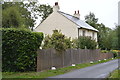
1
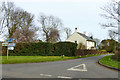
Ivy House
On a short lane between St. Mary's Road (this end) and Jefferstone Lane.
Image: © Robin Webster
Taken: 17 Mar 2017
0.01 miles
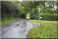
7
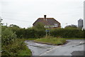
St Mary's Road junction with School Farm Lane
As the signpost says, it's left to St Mary in the Marsh Church (hence the name of this lane?) or, for those of another persuasion, The Star Inn.
Image: © Stuart Logan
Taken: 27 Aug 2011
0.07 miles