IMAGES TAKEN NEAR TO
Brenzett, ROMNEY MARSH, TN29 0BE
Introduction
This page details the photographs taken nearby to TN29 0BE by members of the Geograph project.
The Geograph project started in 2005 with the aim of publishing, organising and preserving representative images for every square kilometre of Great Britain, Ireland and the Isle of Man.

There are currently over 7.5m images from over14,400 individuals and you can help contribute to the project by visiting https://www.geograph.org.uk
Image Map
Images are licensed for reuse under creativecommons.org/licenses/by-sa/2.0
Notes
- Clicking on the map will re-center to the selected point.
- The higher the marker number, the further away the image location is from the centre of the postcode.
Image Listing (9 Images Found)
Images are licensed for reuse under creativecommons.org/licenses/by-sa/2.0
Image
Details
Distance
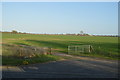
1
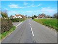
Brenzett Green
A mile or so to the north east of Brenzett. The road, which was once the B2081, is now a quiet back road as the A2070 bypasses it (out of frame on the right). Sunrise Cottage and Shepherds Delight are on the left, Thatched Cottage is to the right.
Image: © Simon Carey
Taken: 8 Apr 2007
0.01 miles
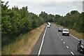
2
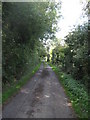
Lane near Brenzett Green
This narrow lane leads from the Brenzett and Snave road, towards Codhall and then towards Whitehall Farm.
Image: © David Anstiss
Taken: 29 Aug 2010
0.06 miles
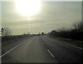
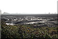
3

Lane to Brenzett Green
Looking towards its junction with the former B2070.
Image: © Simon Carey
Taken: 8 Apr 2007
0.08 miles
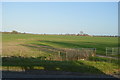
5
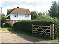
Poplar Farm
As seen from the lane from Brenzett Green towards Snave.
Image: © David Anstiss
Taken: 29 Aug 2010
0.14 miles