IMAGES TAKEN NEAR TO
Queens Road, NEW ROMNEY, TN28 8LT
Introduction
This page details the photographs taken nearby to Queens Road, TN28 8LT by members of the Geograph project.
The Geograph project started in 2005 with the aim of publishing, organising and preserving representative images for every square kilometre of Great Britain, Ireland and the Isle of Man.

There are currently over 7.5m images from over14,400 individuals and you can help contribute to the project by visiting https://www.geograph.org.uk
Image Map
Images are licensed for reuse under creativecommons.org/licenses/by-sa/2.0
Notes
- Clicking on the map will re-center to the selected point.
- The higher the marker number, the further away the image location is from the centre of the postcode.
Image Listing (94 Images Found)
Images are licensed for reuse under creativecommons.org/licenses/by-sa/2.0
Image
Details
Distance
1
Land adjoining 113, Queen's Road
Planning permission has been approved, with conditions, by Folkestone and Hythe District Council under application number 22/1015/FH for the “construction of new custom built, passivhaus dwelling”.
Image: © John Baker
Taken: 25 Sep 2022
0.02 miles
5
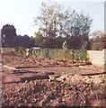
Site for Framlingham 90, St Nicholas Road, 1977
Taken by my father, George Baker. Compared with Image, work has started to level the site.
Image: © George Baker
Taken: Unknown
0.09 miles
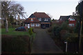
7
Framlingham, 90 St Nicholas Road, Littlestone in 1978
This was the house my parents had built for their retirement and was named after Framlingham Court in Ipswich see http://www.geograph.org.uk/photo/1348289 where they had started married life in 1943. The house was sold in 1995 for £66,000 as the plan was for them to move to Springwood Court, New Romney see http://www.geograph.org.uk/photo/1822238
Image: © John Baker
Taken: 30 Apr 1978
0.10 miles
8
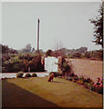
The front garden of Framlingham, 90, St Nicholas Road, 1980
Taken by my father George Baker, the family dog, Emma, poses on the lawn. The outlook, beyond the garden wall, was of wasteland with two of the houses in St Andrew’s Road beyond.
Image: © George Baker
Taken: Unknown
0.10 miles
9
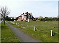
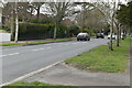
The Red House, Madeira Road, Littlestone
It was owned in the 1930s by Major Max Teichman-Derville but was subsequently converted into flats. The house stands very near to Littlestone Road (also known locally as The Avenue) along which a car can be seen to be travelling.
Image: © John Baker
Taken: 6 Apr 2010
0.10 miles
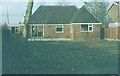
10
Building plot, St Nicholas Road, Littlestone in 1977
This was situated in what had formerly been the garden of The Red House, Madeira Road, Littlestone and was the site for the house my parents had built for £10,000; the plot cost £5,000. In 1994, the house was sold for £66,000.
Image: © John Baker
Taken: 29 Aug 1977
0.11 miles