IMAGES TAKEN NEAR TO
Cockreed Lane, NEW ROMNEY, TN28 8JH
Introduction
This page details the photographs taken nearby to Cockreed Lane, TN28 8JH by members of the Geograph project.
The Geograph project started in 2005 with the aim of publishing, organising and preserving representative images for every square kilometre of Great Britain, Ireland and the Isle of Man.

There are currently over 7.5m images from over14,400 individuals and you can help contribute to the project by visiting https://www.geograph.org.uk
Image Map
Images are licensed for reuse under creativecommons.org/licenses/by-sa/2.0
Notes
- Clicking on the map will re-center to the selected point.
- The higher the marker number, the further away the image location is from the centre of the postcode.
Image Listing (90 Images Found)
Images are licensed for reuse under creativecommons.org/licenses/by-sa/2.0
Image
Details
Distance

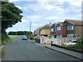
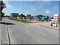
4
Houses under construction, Cockreed Lane
The houses are being built on the Image as part of a new development of houses, known as Mulberry Place, which is being built on the site of the former Image
Planning permission was approved, with conditions, by Folkestone and Hythe District Council under application number Y10/0698/SH for an “outline application for 48 houses and 8 home worker houses (live work) including rotation of an existing dwelling (Greenacres) and off site highway works to Rolfe Lane”.
Image: © John Baker
Taken: 28 Jan 2018
0.09 miles
5
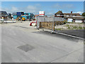
Contractors? site, Cockreed Lane
The site is on a new development of houses, known as Mulberry Place, which is being built on the site of the former Image The house, on the right, is Greenacres (mentioned in the planning application below).
Planning permission was approved, with conditions, by Folkestone and Hythe District Council under application number Y10/0698/SH for an “outline application for 48 houses and 8 home worker houses (live work) including rotation of an existing dwelling (Greenacres) and off site highway works to Rolfe Lane”.
Image: © John Baker
Taken: 11 Jun 2017
0.09 miles
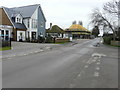
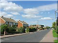
6
Contractors? site, Cockreed Lane
The site is on a new development of houses, known as Mulberry Place, which is being built on the site of the former Image The bungalow, beyond the site, is called Sunnyside.
Planning permission was approved, with conditions, by Folkestone and Hythe District Council under application number Y10/0698/SH for an “outline application for 48 houses and 8 home worker houses (live work) including rotation of an existing dwelling (Greenacres) and off site highway works to Rolfe Lane”.
Image: © John Baker
Taken: 11 Jun 2017
0.09 miles
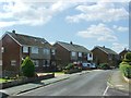
7
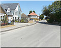
Cockreed Lane
The Image have been completed and numbered 2 to 12 (evens).
The development has been named Mulberry Place.
Image: © John Baker
Taken: 8 Jul 2018
0.09 miles
9
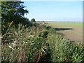
Footpath near New Romney
This footpath leads away from St Mary's Road, just north of New Romney, and ambles along by the field boundaries.
Image: © Marathon
Taken: 22 Oct 2011
0.12 miles
10
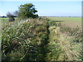
Footpath from St Mary's Road
This footpath leads away from St Mary's Road, just north of New Romney, and ambles along by the field boundaries.
Image: © Marathon
Taken: 22 Oct 2011
0.12 miles