IMAGES TAKEN NEAR TO
Mabledon Close, NEW ROMNEY, TN28 8HT
Introduction
This page details the photographs taken nearby to Mabledon Close, TN28 8HT by members of the Geograph project.
The Geograph project started in 2005 with the aim of publishing, organising and preserving representative images for every square kilometre of Great Britain, Ireland and the Isle of Man.

There are currently over 7.5m images from over14,400 individuals and you can help contribute to the project by visiting https://www.geograph.org.uk
Image Map
Images are licensed for reuse under creativecommons.org/licenses/by-sa/2.0
Notes
- Clicking on the map will re-center to the selected point.
- The higher the marker number, the further away the image location is from the centre of the postcode.
Image Listing (389 Images Found)
Images are licensed for reuse under creativecommons.org/licenses/by-sa/2.0
Image
Details
Distance
1
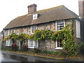
Fairfield House, New Romney
Grade II Listed Building on Fairfield Road, opposite Mabledon Close.
See http://www.britishlistedbuildings.co.uk/en-175021-fairfield-house-new-romney for more details on the house.
Image: © David Anstiss
Taken: 7 Nov 2010
0.03 miles
2
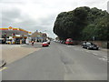
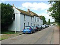
New Romney, High Street
New Romney, High Street.
New Romney is a small town in Kent, England, on Romney Marsh, an area of flat, rich agricultural land reclaimed from the sea after the harbour began to be silted up at Portus Lemanis. New Romney was once a sea port at the mouth of the River Rother, with the harbour adjacent to the church, but is now more than a mile from the sea. It is the headquarters of the Romney, Hythe and Dymchurch Railway.
New Romney is not significantly different in age from the nearby village of Old Romney.
Image: © Helmut Zozmann
Taken: 27 Jul 2011
0.04 miles
3
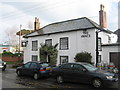
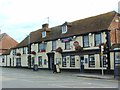
The Prince of Wales, Public House, New Romney
On the junction of Fairfield Road (in front) and George Lane (behind the pub).
Image: © David Anstiss
Taken: 7 Nov 2010
0.04 miles
4
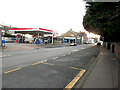
Esso Filling Station, High Street
Fuel was priced at £149.9 for a litre of unleaded petrol and £152.9 for a litre of diesel.
Image: © John Baker
Taken: 6 Feb 2022
0.04 miles
5
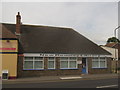
New Romney Library
On the A259 High Street.
Image: © David Anstiss
Taken: 3 Jul 2010
0.05 miles
6
High House, High Street
An early 19th century, grade II, listed house https://britishlistedbuildings.co.uk/101025292-high-house-new-romney#.Yh0bwSvP3cc which appears to be undergoing a major refurbishment.
A similar view of Image from the southwest.
Image: © John Baker
Taken: 6 Feb 2022
0.05 miles
7
High House, High Street
An early 19th century, grade II, listed house https://britishlistedbuildings.co.uk/101025292-high-house-new-romney#.Yh0bwSvP3cc which appears to be undergoing a major refurbishment.
A similar view of Image from the east-northeast.
Image: © John Baker
Taken: 6 Feb 2022
0.05 miles