IMAGES TAKEN NEAR TO
Ruben Crescent, NEW ROMNEY, TN28 8FW
Introduction
This page details the photographs taken nearby to Ruben Crescent, TN28 8FW by members of the Geograph project.
The Geograph project started in 2005 with the aim of publishing, organising and preserving representative images for every square kilometre of Great Britain, Ireland and the Isle of Man.

There are currently over 7.5m images from over14,400 individuals and you can help contribute to the project by visiting https://www.geograph.org.uk
Image Map (Loading...)


Getting Data...Please wait
Leaflet Map data © OpenStreetMap
Images are licensed for reuse under creativecommons.org/licenses/by-sa/2.0
Notes
- Clicking on the map will re-center to the selected point.
- The higher the marker number, the further away the image location is from the centre of the postcode.
Image Listing (106 Images Found)
Images are licensed for reuse under creativecommons.org/licenses/by-sa/2.0
Image
Details
Distance
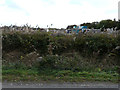
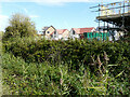
1
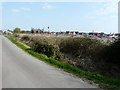
Building site, Cockreed Lane
Planning permission was approved, with conditions, by Folkestone and Hythe District Council under application number Y15/0164/SH for an “outline application for development of up to 110 dwellings with supporting infrastructure”.
The location was given as land bounded by Cockreed Lane and Rolfe Lane (also known as land opposite Dorland).
The development has been named Mulberry Place.
This was the Image in October 2018.
Image: © John Baker
Taken: 1 Apr 2019
0.01 miles
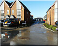
2
Ruben Crescent
Planning permission was approved, with conditions, by Folkestone and Hythe District Council under application number Y15/0164/SH for an “outline application for development of up to 110 dwellings with supporting infrastructure”.
The location was given as land bounded by Cockreed Lane and Rolfe Lane (also known as land opposite Dorland).
The development has been named Mulberry Place.
Image: © John Baker
Taken: 17 Dec 2020
0.02 miles
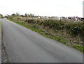
3
Building site, Cockreed Lane
Planning permission was approved, with conditions, by Folkestone and Hythe District Council under application number Y15/0164/SH for an “outline application for development of up to 110 dwellings with supporting infrastructure”.
The location was given as land bounded by Cockreed Lane and Rolfe Lane (also known as land opposite Dorland).
The development has been named Mulberry Place.
A similar image of the Image was taken in October 2018.
Image: © John Baker
Taken: 28 Jan 2018
0.02 miles
4
Ruben Crescent
Planning permission was approved, with conditions, by Folkestone and Hythe District Council under application number Y15/0164/SH for an “outline application for development of up to 110 dwellings with supporting infrastructure”.
The location was given as land bounded by Cockreed Lane and Rolfe Lane (also known as land opposite Dorland).
The development has been named Mulberry Place.
Image: © John Baker
Taken: 17 Dec 2020
0.02 miles
5
Building site, Cockreed Lane
Planning permission was approved, with conditions, by Folkestone and Hythe District Council under application number Y15/0164/SH for an “outline application for development of up to 110 dwellings with supporting infrastructure”.
The location was given as land bounded by Cockreed Lane and Rolfe Lane (also known as land opposite Dorland).
The development has been named Mulberry Place.
A similar image of the Image was taken in January 2018.
Image: © John Baker
Taken: 28 Oct 2018
0.02 miles
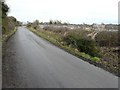
6
Building site, Cockreed Lane
Planning permission was approved, with conditions, by Folkestone and Hythe District Council under application number Y15/0164/SH for an “outline application for development of up to 110 dwellings with supporting infrastructure”.
The location was given as land bounded by Cockreed Lane and Rolfe Lane (also known as land opposite Dorland).
The development has been named Mulberry Place.
A similar image of the Image was taken in January 2018.
Image: © John Baker
Taken: 28 Oct 2018
0.03 miles
7
Building site, Cockreed Lane
Planning permission was approved, with conditions, by Folkestone and Hythe District Council under application number Y15/0164/SH for an “outline application for development of up to 110 dwellings with supporting infrastructure”.
The location was given as land bounded by Cockreed Lane and Rolfe Lane (also known as land opposite Dorland).
The development has been named Mulberry Place.
This was Image in January 2018.
Image: © John Baker
Taken: 6 Sep 2020
0.03 miles
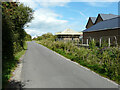
8
Pearmain Way
Planning permission was approved, with conditions, by Folkestone and Hythe District Council under application number Y15/0164/SH for an “outline application for development of up to 110 dwellings with supporting infrastructure”.
The location was given as land bounded by Cockreed Lane and Rolfe Lane (also known as land opposite Dorland).
Pearmain Way runs as far as the Image
Image: © John Baker
Taken: 1 Apr 2019
0.03 miles
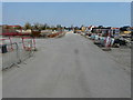
9
Building site, Cockreed Lane
Planning permission was approved, with conditions, by Folkestone and Hythe District Council under application number Y15/0164/SH for an “outline application for development of up to 110 dwellings with supporting infrastructure”.
The location was given as land bounded by Cockreed Lane and Rolfe Lane (also known as land opposite Dorland).
The development has been named Mulberry Place.
Image: © John Baker
Taken: 6 Sep 2020
0.03 miles
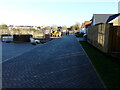
10
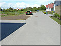
Ruben Crescent
This was Image before the left hand side of the road had builders’ machinery and other items removed. The present view shows a basic fence has been erected and ground that is awaiting grass turves to be laid.
The road is on a development named Mulberry Place.
Image: © John Baker
Taken: 20 Jun 2021
0.03 miles