IMAGES TAKEN NEAR TO
Station Road, ASHFORD, TN27 9SB
Introduction
This page details the photographs taken nearby to Station Road, TN27 9SB by members of the Geograph project.
The Geograph project started in 2005 with the aim of publishing, organising and preserving representative images for every square kilometre of Great Britain, Ireland and the Isle of Man.

There are currently over 7.5m images from over14,400 individuals and you can help contribute to the project by visiting https://www.geograph.org.uk
Image Map
Images are licensed for reuse under creativecommons.org/licenses/by-sa/2.0
Notes
- Clicking on the map will re-center to the selected point.
- The higher the marker number, the further away the image location is from the centre of the postcode.
Image Listing (295 Images Found)
Images are licensed for reuse under creativecommons.org/licenses/by-sa/2.0
Image
Details
Distance
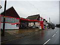
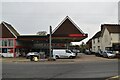
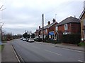
3
A274 in Headcorn
This 'A' road is called Station road but will soon become High Street.
Image: © Stuart Logan
Taken: 16 Jan 2012
0.02 miles
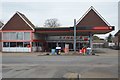
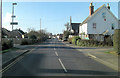
5
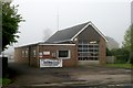
Headcorn fire station
Headcorn fire station, 16 Station Road, Headcorn, Ashford, Kent, on a foggy late April morning
Image: © Kevin Hale
Taken: 28 Apr 2009
0.02 miles