IMAGES TAKEN NEAR TO
Rosemead Gardens, ASHFORD, TN27 9RT
Introduction
This page details the photographs taken nearby to Rosemead Gardens, TN27 9RT by members of the Geograph project.
The Geograph project started in 2005 with the aim of publishing, organising and preserving representative images for every square kilometre of Great Britain, Ireland and the Isle of Man.

There are currently over 7.5m images from over14,400 individuals and you can help contribute to the project by visiting https://www.geograph.org.uk
Image Map
Images are licensed for reuse under creativecommons.org/licenses/by-sa/2.0
Notes
- Clicking on the map will re-center to the selected point.
- The higher the marker number, the further away the image location is from the centre of the postcode.
Image Listing (12 Images Found)
Images are licensed for reuse under creativecommons.org/licenses/by-sa/2.0
Image
Details
Distance
6
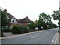
Oast House at Stonestile House, Stonestile Road, Headcorn, Kent
Image: © Oast House Archive
Taken: 30 Jan 2008
0.17 miles
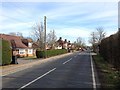
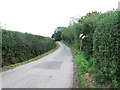
7

Plumtree Road
This is the view from the road junction of Plumtree Road with Stonestile Road and Dray Corner Road.
Image: © Marathon
Taken: 16 Jan 2022
0.21 miles
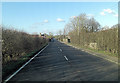
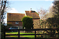
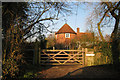
8

Ramhurst Farmhouse
There is an oast house at Ramhurst Farm - see https://www.geograph.org.uk/photo/637114 for more information. This is the view from Stonestile Road.
Image: © Marathon
Taken: 16 Jan 2022
0.22 miles
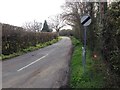
10
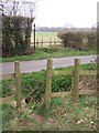
Footpath crosses Tattlebury Road
Path from Tong Lane (byway) leads through orchard, then over road, then through field to Ulcombe Road, Headcorn.
Image: © David Anstiss
Taken: 19 Mar 2009
0.23 miles