IMAGES TAKEN NEAR TO
Forge Meadows, ASHFORD, TN27 9QW
Introduction
This page details the photographs taken nearby to Forge Meadows, TN27 9QW by members of the Geograph project.
The Geograph project started in 2005 with the aim of publishing, organising and preserving representative images for every square kilometre of Great Britain, Ireland and the Isle of Man.

There are currently over 7.5m images from over14,400 individuals and you can help contribute to the project by visiting https://www.geograph.org.uk
Image Map (Loading...)


Getting Data...Please wait
Leaflet Map data © OpenStreetMap
Images are licensed for reuse under creativecommons.org/licenses/by-sa/2.0
Notes
- Clicking on the map will re-center to the selected point.
- The higher the marker number, the further away the image location is from the centre of the postcode.
Image Listing (307 Images Found)
Images are licensed for reuse under creativecommons.org/licenses/by-sa/2.0
Image
Details
Distance

10
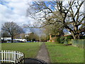
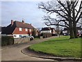
Path alongside the village green in Headcorn
The village green is behind the High Street to the north. It is bounded to the north by Kings Road and to the west by North Street, and on the other two sides by houses. This view looks towards Kings Road with the village primary school visible on the other side of the road.
Image: © Marathon
Taken: 21 Feb 2015
0.07 miles