IMAGES TAKEN NEAR TO
Plumtree Road, ASHFORD, TN27 9PE
Introduction
This page details the photographs taken nearby to Plumtree Road, TN27 9PE by members of the Geograph project.
The Geograph project started in 2005 with the aim of publishing, organising and preserving representative images for every square kilometre of Great Britain, Ireland and the Isle of Man.

There are currently over 7.5m images from over14,400 individuals and you can help contribute to the project by visiting https://www.geograph.org.uk
Image Map
Images are licensed for reuse under creativecommons.org/licenses/by-sa/2.0
Notes
- Clicking on the map will re-center to the selected point.
- The higher the marker number, the further away the image location is from the centre of the postcode.
Image Listing (8 Images Found)
Images are licensed for reuse under creativecommons.org/licenses/by-sa/2.0
Image
Details
Distance
1
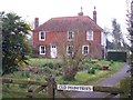
Old Plum Trees
On Plumtree Road. Part of Plumtree Farm.
Image: © David Anstiss
Taken: 19 Mar 2009
0.03 miles
2
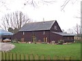
Plumtree Farm
Converted barn on Plumtree Road.
Image: © David Anstiss
Taken: 19 Mar 2009
0.04 miles
3

Plumtree House
On Plumtree Road. Part of Plumtree Farm.
Image: © David Anstiss
Taken: 19 Mar 2009
0.06 miles
4

Stream Near Stonestile Rd
Looking downstream
Image: © Glyn Baker
Taken: 17 Feb 2019
0.22 miles
5
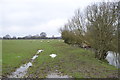
Waterlogged field with sheep
A footpath runs along the edge of the stream towards Plumtree Road.
Image: © Julian P Guffogg
Taken: 10 Mar 2013
0.22 miles
6

Not a Stone Stile!
The footpath to Plumbtree Road starts at the Junction of Stonestile Road and Dray Corner Road. Clearly the roads is not named after this stile.
Image: © Glyn Baker
Taken: 17 Feb 2019
0.22 miles
7
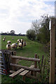
Sheep by the stile
The sheep were eager to pose for their photograph.
Image: © Robin Webster
Taken: 9 Apr 2007
0.22 miles
8

Curious cattle
The herd trotted over towards me when they spotted me at the gate, and then had second thoughts.
Image: © Robin Webster
Taken: 22 May 2012
0.25 miles