IMAGES TAKEN NEAR TO
Summerhill, ASHFORD, TN27 9NX
Introduction
This page details the photographs taken nearby to Summerhill, TN27 9NX by members of the Geograph project.
The Geograph project started in 2005 with the aim of publishing, organising and preserving representative images for every square kilometre of Great Britain, Ireland and the Isle of Man.

There are currently over 7.5m images from over14,400 individuals and you can help contribute to the project by visiting https://www.geograph.org.uk
Image Map
Images are licensed for reuse under creativecommons.org/licenses/by-sa/2.0
Notes
- Clicking on the map will re-center to the selected point.
- The higher the marker number, the further away the image location is from the centre of the postcode.
Image Listing (16 Images Found)
Images are licensed for reuse under creativecommons.org/licenses/by-sa/2.0
Image
Details
Distance
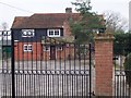
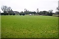
1
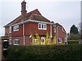
Summerhill House
On access road from Summerhill road. Part of Summerhill Farm.
Image: © David Anstiss
Taken: 19 Mar 2009
0.03 miles
3
Billiards House
On access road from Summerhill road.
Image: © David Anstiss
Taken: 19 Mar 2009
0.05 miles
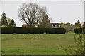
8
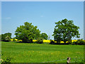
Hedgerow trees
A public footpath runs along this side of the hedgerow.
Image: © Robin Webster
Taken: 22 May 2012
0.11 miles