IMAGES TAKEN NEAR TO
Moat Road, ASHFORD, TN27 9NT
Introduction
This page details the photographs taken nearby to Moat Road, TN27 9NT by members of the Geograph project.
The Geograph project started in 2005 with the aim of publishing, organising and preserving representative images for every square kilometre of Great Britain, Ireland and the Isle of Man.

There are currently over 7.5m images from over14,400 individuals and you can help contribute to the project by visiting https://www.geograph.org.uk
Image Map
Images are licensed for reuse under creativecommons.org/licenses/by-sa/2.0
Notes
- Clicking on the map will re-center to the selected point.
- The higher the marker number, the further away the image location is from the centre of the postcode.
Image Listing (275 Images Found)
Images are licensed for reuse under creativecommons.org/licenses/by-sa/2.0
Image
Details
Distance

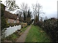
4
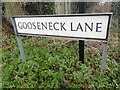
An unusual name
Gooseneck Lane is just off Moat Road on the western edge of Headcorn. It is very intriguing.
Image: © Marathon
Taken: 12 Feb 2022
0.03 miles
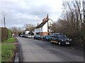
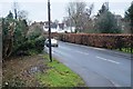
5

Roadworks in Moat Road
Even on a Sunday the works were causing delays on the Maidstone Road.
Image: © Glyn Baker
Taken: 17 Feb 2019
0.04 miles
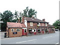
7
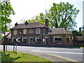
The White Horse, Headcorn
On the A274, North Street.
Image: © Robin Webster
Taken: 22 May 2012
0.04 miles