IMAGES TAKEN NEAR TO
Grigg Lane, ASHFORD, TN27 9LS
Introduction
This page details the photographs taken nearby to Grigg Lane, TN27 9LS by members of the Geograph project.
The Geograph project started in 2005 with the aim of publishing, organising and preserving representative images for every square kilometre of Great Britain, Ireland and the Isle of Man.

There are currently over 7.5m images from over14,400 individuals and you can help contribute to the project by visiting https://www.geograph.org.uk
Image Map
Images are licensed for reuse under creativecommons.org/licenses/by-sa/2.0
Notes
- Clicking on the map will re-center to the selected point.
- The higher the marker number, the further away the image location is from the centre of the postcode.
Image Listing (43 Images Found)
Images are licensed for reuse under creativecommons.org/licenses/by-sa/2.0
Image
Details
Distance
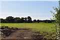
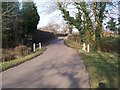
2
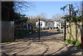
Gateway off Grigg Lane, near Glover's Bridge
Image: © N Chadwick
Taken: 9 Mar 2014
0.02 miles
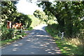
4
Glover's Bridge
Grigg Lane crosses a small tributary stream of the River Sherway. See Image
Image: © N Chadwick
Taken: 9 Mar 2014
0.04 miles
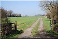
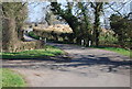
6
Glover's Bridge
Grigg Lane goes over River Sherway, from Headcorn to Potter's Forstal.
Image: © David Anstiss
Taken: 11 Mar 2009
0.04 miles
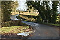
7
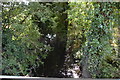
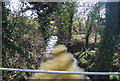
Stream at Glover's Bridge
A tributary of the River Sherway.
Image: © N Chadwick
Taken: 29 Aug 2019
0.05 miles