IMAGES TAKEN NEAR TO
Lenham Road, ASHFORD, TN27 9LQ
Introduction
This page details the photographs taken nearby to Lenham Road, TN27 9LQ by members of the Geograph project.
The Geograph project started in 2005 with the aim of publishing, organising and preserving representative images for every square kilometre of Great Britain, Ireland and the Isle of Man.

There are currently over 7.5m images from over14,400 individuals and you can help contribute to the project by visiting https://www.geograph.org.uk
Image Map
Images are licensed for reuse under creativecommons.org/licenses/by-sa/2.0
Notes
- Clicking on the map will re-center to the selected point.
- The higher the marker number, the further away the image location is from the centre of the postcode.
Image Listing (12 Images Found)
Images are licensed for reuse under creativecommons.org/licenses/by-sa/2.0
Image
Details
Distance
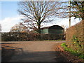
4
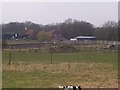
Barling Green Farm
On Lenham Road. Seen from footpath from Southernden Road to Lenham Road.
Image: © David Anstiss
Taken: 19 Mar 2009
0.06 miles
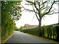
5
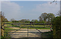
Gates and fences
And a horse who decided to start grazing again at the wrong moment!
Image: © Robin Webster
Taken: 9 Apr 2007
0.09 miles
7
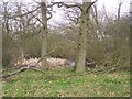
Pond in Barling Green Farm
As seen from footpath from Southernden Road to Lenham Road, via farm.
Image: © David Anstiss
Taken: 19 Mar 2009
0.19 miles
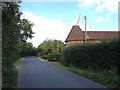
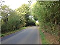
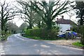
9
Junction of Bakers Lane with Lenham Road
Image: © Oast House Archive
Taken: 19 Nov 2008
0.22 miles
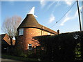
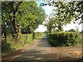
10
Sunnyside Farm
By the junction of Baker Lane, just visible on the left, and Lenham Road.
Image: © Robin Webster
Taken: 9 Apr 2007
0.22 miles