IMAGES TAKEN NEAR TO
Biddenden Road, ASHFORD, TN27 9LF
Introduction
This page details the photographs taken nearby to Biddenden Road, TN27 9LF by members of the Geograph project.
The Geograph project started in 2005 with the aim of publishing, organising and preserving representative images for every square kilometre of Great Britain, Ireland and the Isle of Man.

There are currently over 7.5m images from over14,400 individuals and you can help contribute to the project by visiting https://www.geograph.org.uk
Image Map
Images are licensed for reuse under creativecommons.org/licenses/by-sa/2.0
Notes
- Clicking on the map will re-center to the selected point.
- The higher the marker number, the further away the image location is from the centre of the postcode.
Image Listing (24 Images Found)
Images are licensed for reuse under creativecommons.org/licenses/by-sa/2.0
Image
Details
Distance
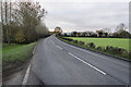
4
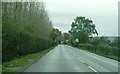
Biddenden Road
This is the A274, heading south from Headcorn
Image: © Clint Mann
Taken: 30 Oct 2015
0.04 miles
5
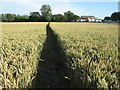
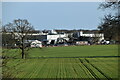
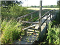
Footpath towards the Dairy
This path leads from Headcorn Railway Station (via a footbridge) through a field past the Dairy (a large milk processing factory, seen on the right), then over the River Beult to Waterman Quarter. Note: OS Map shows other footpaths and footbridges in this field. They are not shown in the field.
Image: © David Anstiss
Taken: 5 Jul 2009
0.05 miles
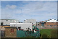
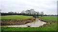
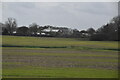
9
Footbridge over River Beult, near the Dairy
This bridge is on a footpath from Bletchenden, Waterman Quarter to Headcorn Railway Station. The Dairy is a large milk processing factory on the other side of the river.
Image: © David Anstiss
Taken: 5 Jul 2009
0.15 miles