IMAGES TAKEN NEAR TO
Ayleswade Lane, ASHFORD, TN27 9JG
Introduction
This page details the photographs taken nearby to Ayleswade Lane, TN27 9JG by members of the Geograph project.
The Geograph project started in 2005 with the aim of publishing, organising and preserving representative images for every square kilometre of Great Britain, Ireland and the Isle of Man.

There are currently over 7.5m images from over14,400 individuals and you can help contribute to the project by visiting https://www.geograph.org.uk
Image Map
Images are licensed for reuse under creativecommons.org/licenses/by-sa/2.0
Notes
- Clicking on the map will re-center to the selected point.
- The higher the marker number, the further away the image location is from the centre of the postcode.
Image Listing (14 Images Found)
Images are licensed for reuse under creativecommons.org/licenses/by-sa/2.0
Image
Details
Distance
2
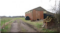
Excavator and Dutch Barn, Waterman Lane
This rusty digger machine is beside this open barn on the lane.
Image: © David Anstiss
Taken: 5 Jul 2009
0.04 miles
3
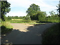
Lane junction on Ayleswade Lane
Waterman Lane (from Headcorn) meets Aylewade Lane (heading left to A274 Biddenden Road from Lashenden A274 Headcorn Road). A footpath heads over the gate, toward A274 Biddenden Road, near Tile Barn Farm.
Image: © David Anstiss
Taken: 5 Jul 2009
0.05 miles
5
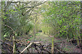
Course of Kent & East Sussex Railway
The section of the K&ESR from Headcorn to Tenterden has been abandoned. Looking rather like a Roman road, complete with a nearby Coldharbour Farm.
Image: © Robin Webster
Taken: 9 Apr 2007
0.09 miles
6
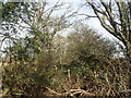
The former line of the Kent & East Sussex Railway
It is hard to believe that there was once a level crossing and a railway line here. It was once the line of the Kent & East Sussex Railway.
The original line was opened by the Rother Valley Railway between Rolvenden and Robertsbridge in 1900. The railway extended to Tenterden Town in 1903 and on to Headcorn in 1905, naming itself the Kent & East Sussex Railway in the process. The part between Tenterden Town and Bodiam is now part of the heritage Kent & East Sussex Railway but the section from Tenterden Town to Headcorn closed in 1954 and it is hard sometimes to imagine that it ever existed. The next station in this direction was Headcorn. See also https://www.geograph.org.uk/photo/7094984
Image: © Marathon
Taken: 12 Feb 2022
0.09 miles
7
Crossing the line of the former Kent & East Sussex Railway
It is hard to believe that there was once a level crossing a few yards in front of where I am standing. It was once the line of the Kent & East Sussex Railway.
The original line was opened by the Rother Valley Railway between Rolvenden and Robertsbridge in 1900. The railway extended to Tenterden Town in 1903 and on to Headcorn in 1905, naming itself the Kent & East Sussex Railway in the process. The part between Tenterden Town and Bodiam is now part of the heritage Kent & East Sussex Railway but the section from Tenterden Town to Headcorn closed in 1954 and it is hard sometimes to imagine that it ever existed. The next station to the right was Headcorn and to the left was Frittenden Road. See also https://www.geograph.org.uk/photo/7094988
Image: © Marathon
Taken: 12 Feb 2022
0.12 miles

10
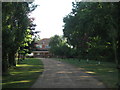
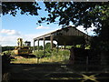
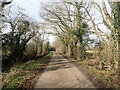
Tree line road to Coldharbour Farm
This private road leads from Waterman Lane.
Image: © David Anstiss
Taken: 5 Jul 2009
0.18 miles