IMAGES TAKEN NEAR TO
Biddenden Road, ASHFORD, TN27 9JE
Introduction
This page details the photographs taken nearby to Biddenden Road, TN27 9JE by members of the Geograph project.
The Geograph project started in 2005 with the aim of publishing, organising and preserving representative images for every square kilometre of Great Britain, Ireland and the Isle of Man.

There are currently over 7.5m images from over14,400 individuals and you can help contribute to the project by visiting https://www.geograph.org.uk
Image Map (Loading...)


Getting Data...Please wait
Leaflet Map data © OpenStreetMap
Images are licensed for reuse under creativecommons.org/licenses/by-sa/2.0
Notes
- Clicking on the map will re-center to the selected point.
- The higher the marker number, the further away the image location is from the centre of the postcode.
Image Listing (7 Images Found)
Images are licensed for reuse under creativecommons.org/licenses/by-sa/2.0
Image
Details
Distance
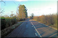

5
A274 at Wick Hill
Southwards, between Headcorn and Biddenden
Image: © Clint Mann
Taken: 30 Oct 2015
0.22 miles
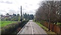
6
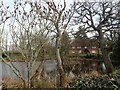
Links Farm
The view of the attractive farmhouse is seen across its pond from Ayleswade Lane.
Image: © Marathon
Taken: 12 Feb 2022
0.23 miles
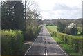
7
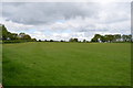
Field off Ayleswade Lane
Lush grass at this time.
Image: © Julian P Guffogg
Taken: 27 Apr 2014
0.23 miles