IMAGES TAKEN NEAR TO
Field Mill Road, ASHFORD, TN27 9AU
Introduction
This page details the photographs taken nearby to Field Mill Road, TN27 9AU by members of the Geograph project.
The Geograph project started in 2005 with the aim of publishing, organising and preserving representative images for every square kilometre of Great Britain, Ireland and the Isle of Man.

There are currently over 7.5m images from over14,400 individuals and you can help contribute to the project by visiting https://www.geograph.org.uk
Image Map
Images are licensed for reuse under creativecommons.org/licenses/by-sa/2.0
Notes
- Clicking on the map will re-center to the selected point.
- The higher the marker number, the further away the image location is from the centre of the postcode.
Image Listing (23 Images Found)
Images are licensed for reuse under creativecommons.org/licenses/by-sa/2.0
Image
Details
Distance
1
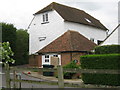
Field Mill
This converted mill building is on Field Mill Road.
Image: © David Anstiss
Taken: 4 May 2009
0.07 miles
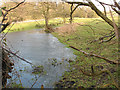
2
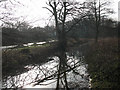
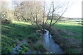
Reflections in the Great Stour
The 'Great' Stour hardly lives up to its name, being more of a tranquil stream.
Image: © Stephen Craven
Taken: 30 Jan 2009
0.10 miles
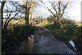
7
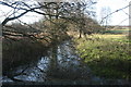
Frozen floodwater
This small pond appears to be the remains of a flood as it is close to the Great Stour river. Sheltered from the sun by a tall hedge, its surface was frozen after a long spell of cold weather.
Image: © Stephen Craven
Taken: 30 Jan 2009
0.13 miles
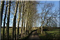
10
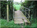
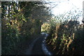
Footbridge on Stour Valley Walk
This bridge on the long distance walk is near Field Mill as the path follows the Great Stour River towards Barnfield. It crosses a side shoot of the river.
Image: © David Anstiss
Taken: 4 May 2009
0.15 miles