IMAGES TAKEN NEAR TO
Bethersden Road, ASHFORD, TN27 8QX
Introduction
This page details the photographs taken nearby to Bethersden Road, TN27 8QX by members of the Geograph project.
The Geograph project started in 2005 with the aim of publishing, organising and preserving representative images for every square kilometre of Great Britain, Ireland and the Isle of Man.

There are currently over 7.5m images from over14,400 individuals and you can help contribute to the project by visiting https://www.geograph.org.uk
Image Map (Loading...)


Getting Data...Please wait
Leaflet Map data © OpenStreetMap
Images are licensed for reuse under creativecommons.org/licenses/by-sa/2.0
Notes
- Clicking on the map will re-center to the selected point.
- The higher the marker number, the further away the image location is from the centre of the postcode.
Image Listing (39 Images Found)
Images are licensed for reuse under creativecommons.org/licenses/by-sa/2.0
Image
Details
Distance
1
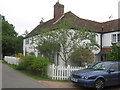
Fetherbridge Cottage, Haffenden Quarter
On Bethersden Road.
Image: © David Anstiss
Taken: 26 Jul 2009
0.04 miles
2
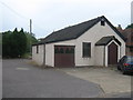
Disused church in Haffenden Quarter
Unused church on Bethersden Road.
Image: © David Anstiss
Taken: 26 Jul 2009
0.07 miles
5
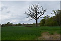
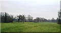
Single bare Tree
In a Crop field near Smarden. St Michael's church tower is visible in the distance.
Image: © Julian P Guffogg
Taken: 27 Apr 2014
0.12 miles
6
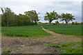
Public Footpath across a crop field
Heading in the direction of the River Beult.
Image: © Julian P Guffogg
Taken: 27 Apr 2014
0.12 miles
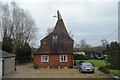
9
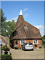
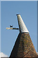
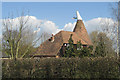
Fleet Farm Oast, Bethersden Road, Smarden
Image: © Oast House Archive
Taken: 19 Jul 2015
0.13 miles