IMAGES TAKEN NEAR TO
Headcorn Road, ASHFORD, TN27 8PJ
Introduction
This page details the photographs taken nearby to Headcorn Road, TN27 8PJ by members of the Geograph project.
The Geograph project started in 2005 with the aim of publishing, organising and preserving representative images for every square kilometre of Great Britain, Ireland and the Isle of Man.

There are currently over 7.5m images from over14,400 individuals and you can help contribute to the project by visiting https://www.geograph.org.uk
Image Map (Loading...)


Getting Data...Please wait
Leaflet Map data © OpenStreetMap
Images are licensed for reuse under creativecommons.org/licenses/by-sa/2.0
Notes
- Clicking on the map will re-center to the selected point.
- The higher the marker number, the further away the image location is from the centre of the postcode.
Image Listing (20 Images Found)
Images are licensed for reuse under creativecommons.org/licenses/by-sa/2.0
Image
Details
Distance
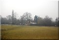
3
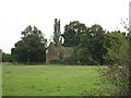
The Oast House, Headcorn Road, Smarden, Kent
Image: © Oast House Archive
Taken: 30 Sep 2007
0.11 miles
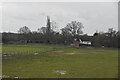
4
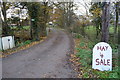
Hay 4 Sale and footpath
The start of a footpath shares an access drive off Headcorn Road.
Image: © Julian P Guffogg
Taken: 30 Nov 2013
0.12 miles
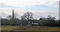
5
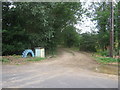
Footpaths on Headcorn Road
A path leads down the farm track to Munks Farm, towards the River Beult and onto Burnthouse Lane, beside the airfield. Another path heads right over a ditch and through a horse field towards Smarden Road.
Image: © David Anstiss
Taken: 26 Jul 2009
0.13 miles