IMAGES TAKEN NEAR TO
Bedlam Lane, ASHFORD, TN27 8PG
Introduction
This page details the photographs taken nearby to Bedlam Lane, TN27 8PG by members of the Geograph project.
The Geograph project started in 2005 with the aim of publishing, organising and preserving representative images for every square kilometre of Great Britain, Ireland and the Isle of Man.

There are currently over 7.5m images from over14,400 individuals and you can help contribute to the project by visiting https://www.geograph.org.uk
Image Map (Loading...)


Getting Data...Please wait
Leaflet Map data © OpenStreetMap
Images are licensed for reuse under creativecommons.org/licenses/by-sa/2.0
Notes
- Clicking on the map will re-center to the selected point.
- The higher the marker number, the further away the image location is from the centre of the postcode.
Image Listing (4 Images Found)
Images are licensed for reuse under creativecommons.org/licenses/by-sa/2.0
Image
Details
Distance
2
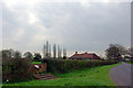
Memorial on Bedlam Lane, near Egerton, Kent
A World War 2 airfield was situated in the neighbouring fields
Image: © Oast House Archive
Taken: 18 Sep 2008
0.15 miles
4
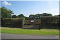
Roadside War Memorial
In memory of those who died between April and July 1944 in the 362nd Fighter group, USAF, and also 403 and 421 squadron of Royal Canadian Air Force.
Nothing of Headcorn Advanced Landing Ground remains.
Image: © Julian P Guffogg
Taken: 30 Nov 2013
0.19 miles