IMAGES TAKEN NEAR TO
Cot Lane, ASHFORD, TN27 8JS
Introduction
This page details the photographs taken nearby to Cot Lane, TN27 8JS by members of the Geograph project.
The Geograph project started in 2005 with the aim of publishing, organising and preserving representative images for every square kilometre of Great Britain, Ireland and the Isle of Man.

There are currently over 7.5m images from over14,400 individuals and you can help contribute to the project by visiting https://www.geograph.org.uk
Image Map
Images are licensed for reuse under creativecommons.org/licenses/by-sa/2.0
Notes
- Clicking on the map will re-center to the selected point.
- The higher the marker number, the further away the image location is from the centre of the postcode.
Image Listing (22 Images Found)
Images are licensed for reuse under creativecommons.org/licenses/by-sa/2.0
Image
Details
Distance
3
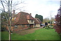
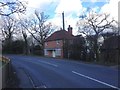
Old Curteis
Grade II listed. http://www.britishlistedbuildings.co.uk/en-180151-old-curteis-27-biddenden
Image: © N Chadwick
Taken: 10 Apr 2012
0.02 miles
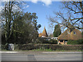
8
Old Curteis Oast, Headcorn Road, Biddenden, Kent
Single round kiln oast house.
Image: © Oast House Archive
Taken: 14 Mar 2007
0.05 miles
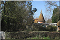
9
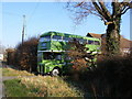
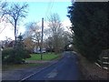
Bus in a front garden!
This Green London Country Bus was spotted in the front garden of a bungalow on the A274 near Biddenden.
Image: © Clive Warneford
Taken: 16 Feb 2008
0.06 miles
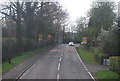
10
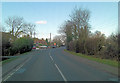
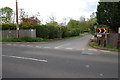
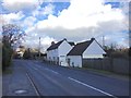
A274 at Curties Corner
At this point the 'A' road is known as North Street but after the settlement it becomes Headcorn Road.
Image: © Stuart Logan
Taken: 16 Jan 2012
0.07 miles