IMAGES TAKEN NEAR TO
Woodlands Park, ASHFORD, TN27 8DB
Introduction
This page details the photographs taken nearby to Woodlands Park, TN27 8DB by members of the Geograph project.
The Geograph project started in 2005 with the aim of publishing, organising and preserving representative images for every square kilometre of Great Britain, Ireland and the Isle of Man.

There are currently over 7.5m images from over14,400 individuals and you can help contribute to the project by visiting https://www.geograph.org.uk
Image Map (Loading...)


Getting Data...Please wait
Leaflet Map data © OpenStreetMap
Images are licensed for reuse under creativecommons.org/licenses/by-sa/2.0
Notes
- Clicking on the map will re-center to the selected point.
- The higher the marker number, the further away the image location is from the centre of the postcode.
Image Listing (31 Images Found)
Images are licensed for reuse under creativecommons.org/licenses/by-sa/2.0
Image
Details
Distance
3
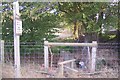
Stile and footbridge near Woodlands Park
This stile is on path from High Halden Road to A262 Biddenden Road.
Woodlands Park is a caravan park.
Image: © David Anstiss
Taken: 4 Oct 2009
0.13 miles

9
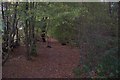
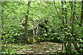
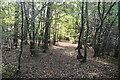
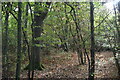
Woodlands near Woodland Park
This wood is on a path from A262 Biddenden Road, past the Woodlands Park Caravan Park and past Hook Wood, towards High Halden Road.
Image: © David Anstiss
Taken: 4 Oct 2009
0.15 miles