IMAGES TAKEN NEAR TO
Tenterden Road, ASHFORD, TN27 8BW
Introduction
This page details the photographs taken nearby to Tenterden Road, TN27 8BW by members of the Geograph project.
The Geograph project started in 2005 with the aim of publishing, organising and preserving representative images for every square kilometre of Great Britain, Ireland and the Isle of Man.

There are currently over 7.5m images from over14,400 individuals and you can help contribute to the project by visiting https://www.geograph.org.uk
Image Map (Loading...)


Getting Data...Please wait
Leaflet Map data © OpenStreetMap
Images are licensed for reuse under creativecommons.org/licenses/by-sa/2.0
Notes
- Clicking on the map will re-center to the selected point.
- The higher the marker number, the further away the image location is from the centre of the postcode.
Image Listing (4 Images Found)
Images are licensed for reuse under creativecommons.org/licenses/by-sa/2.0
Image
Details
Distance
1
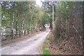
Goldwell Farm Road
This is an access road to the farm, farmhouse and Primrose Cottages from the A262 Tenterden Road. It is also used by a footpath from Gribble Bridge Lane.
Image: © David Anstiss
Taken: 3 Oct 2009
0.06 miles
2
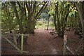
Footpath through Barnfield Wood
This path (No.AB1) is from Bugglesden Road, towards Goldwell Farm and then onto Gribble Bridge Lane.
Image: © David Anstiss
Taken: 4 Oct 2009
0.11 miles
3
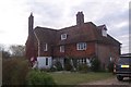
Goldwell Farmhouse
At the end of an access track from The A262 Tenterden Road.
Image: © David Anstiss
Taken: 4 Oct 2009
0.15 miles