IMAGES TAKEN NEAR TO
Cloth Hall Gardens, ASHFORD, TN27 8AT
Introduction
This page details the photographs taken nearby to Cloth Hall Gardens, TN27 8AT by members of the Geograph project.
The Geograph project started in 2005 with the aim of publishing, organising and preserving representative images for every square kilometre of Great Britain, Ireland and the Isle of Man.

There are currently over 7.5m images from over14,400 individuals and you can help contribute to the project by visiting https://www.geograph.org.uk
Image Map
Images are licensed for reuse under creativecommons.org/licenses/by-sa/2.0
Notes
- Clicking on the map will re-center to the selected point.
- The higher the marker number, the further away the image location is from the centre of the postcode.
Image Listing (229 Images Found)
Images are licensed for reuse under creativecommons.org/licenses/by-sa/2.0
Image
Details
Distance
6
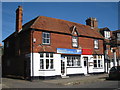
Shops on High Street
What appears to be a former Shepherd Neame pub.
Image: © Oast House Archive
Taken: 11 Oct 2010
0.10 miles
8
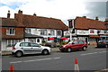
The Red Lion, High Street, Biddenden
Image: © Julian P Guffogg
Taken: 13 May 2012
0.10 miles
9
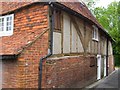
32 High Street, Biddenden
Looking up the alley on the left of Image "C17 or earlier timber-framed building refaced on the ground floor with red brick" http://www.britishlistedbuildings.co.uk/en-180163-32-biddenden .
Image: © Derek Harper
Taken: 21 May 2006
0.10 miles
10
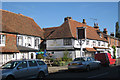
The Red Lion, Biddenden
Grade II listed pub on High Street.
Image: © Oast House Archive
Taken: 11 Oct 2010
0.10 miles