IMAGES TAKEN NEAR TO
The Street, ASHFORD, TN27 0QF
Introduction
This page details the photographs taken nearby to The Street, TN27 0QF by members of the Geograph project.
The Geograph project started in 2005 with the aim of publishing, organising and preserving representative images for every square kilometre of Great Britain, Ireland and the Isle of Man.

There are currently over 7.5m images from over14,400 individuals and you can help contribute to the project by visiting https://www.geograph.org.uk
Image Map (Loading...)


Getting Data...Please wait
Leaflet Map data © OpenStreetMap
Images are licensed for reuse under creativecommons.org/licenses/by-sa/2.0
Notes
- Clicking on the map will re-center to the selected point.
- The higher the marker number, the further away the image location is from the centre of the postcode.
Image Listing (55 Images Found)
Images are licensed for reuse under creativecommons.org/licenses/by-sa/2.0
Image
Details
Distance
5
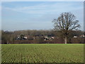
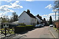
View of Little Chart
From the Greensand Way.
Image: © pam fray
Taken: 14 Dec 2016
0.09 miles
9
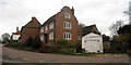
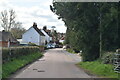
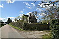
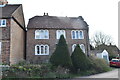
The Cottage, The Street, Little Chart
C17 house with Dutch gable wall and Dering windows.
Grade II listed.
Image: © Oast House Archive
Taken: 1 Dec 2009
0.10 miles
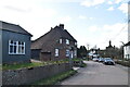
10
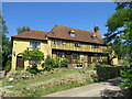
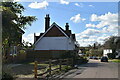
Bank House at Little Chart
Imposing house on the village green.
Image: © David M Clark
Taken: 23 Jun 2020
0.13 miles