IMAGES TAKEN NEAR TO
Pluckley, ASHFORD, TN27 0PP
Introduction
This page details the photographs taken nearby to TN27 0PP by members of the Geograph project.
The Geograph project started in 2005 with the aim of publishing, organising and preserving representative images for every square kilometre of Great Britain, Ireland and the Isle of Man.

There are currently over 7.5m images from over14,400 individuals and you can help contribute to the project by visiting https://www.geograph.org.uk
Image Map
Images are licensed for reuse under creativecommons.org/licenses/by-sa/2.0
Notes
- Clicking on the map will re-center to the selected point.
- The higher the marker number, the further away the image location is from the centre of the postcode.
Image Listing (22 Images Found)
Images are licensed for reuse under creativecommons.org/licenses/by-sa/2.0
Image
Details
Distance
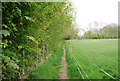
5
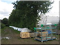
Netting for Orchard in Sheerland Farm
One side of this hedge in Sheerland Farm has an apple orchard covered in netting. The other side is being prepared to be covered.
Image: © David Anstiss
Taken: 2 Aug 2009
0.17 miles
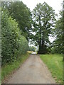
6
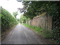
Greensand Way crosses Dowle Street
The long distance path leads right towards Little Chart, from Sheerland Farm and Pluckley.
Image: © David Anstiss
Taken: 2 Aug 2009
0.17 miles
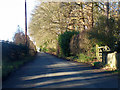
7
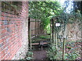
The Greensand Way leads over a Stile
This stile beside Walnut Tree Farm is on the long distance path heading to Little Chart from Pluckley.
Image: © David Anstiss
Taken: 2 Aug 2009
0.17 miles