IMAGES TAKEN NEAR TO
Old Avenue, ASHFORD, TN27 0PH
Introduction
This page details the photographs taken nearby to Old Avenue, TN27 0PH by members of the Geograph project.
The Geograph project started in 2005 with the aim of publishing, organising and preserving representative images for every square kilometre of Great Britain, Ireland and the Isle of Man.

There are currently over 7.5m images from over14,400 individuals and you can help contribute to the project by visiting https://www.geograph.org.uk
Image Map (Loading...)


Getting Data...Please wait
Leaflet Map data © OpenStreetMap
Images are licensed for reuse under creativecommons.org/licenses/by-sa/2.0
Notes
- Clicking on the map will re-center to the selected point.
- The higher the marker number, the further away the image location is from the centre of the postcode.
Image Listing (150 Images Found)
Images are licensed for reuse under creativecommons.org/licenses/by-sa/2.0
Image
Details
Distance
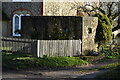
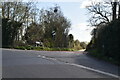
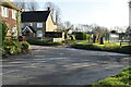
6
Junction of the Egerton, Smarden roads and Swan Lane
'Pill Box', from the time of the Second World War, still in evidence as a reminder of the country's wartime defence.
Image: © Brian Chadwick
Taken: 23 Apr 2014
0.02 miles
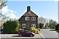
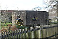
9
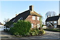
Tollgate House
Grade II listed. https://historicengland.org.uk/listing/the-list/list-entry/1335823
Image: © N Chadwick
Taken: 8 Dec 2019
0.03 miles