IMAGES TAKEN NEAR TO
Faversham Road, ASHFORD, TN27 0NR
Introduction
This page details the photographs taken nearby to Faversham Road, TN27 0NR by members of the Geograph project.
The Geograph project started in 2005 with the aim of publishing, organising and preserving representative images for every square kilometre of Great Britain, Ireland and the Isle of Man.

There are currently over 7.5m images from over14,400 individuals and you can help contribute to the project by visiting https://www.geograph.org.uk
Image Map (Loading...)


Getting Data...Please wait
Leaflet Map data © OpenStreetMap
Images are licensed for reuse under creativecommons.org/licenses/by-sa/2.0
Notes
- Clicking on the map will re-center to the selected point.
- The higher the marker number, the further away the image location is from the centre of the postcode.
Image Listing (11 Images Found)
Images are licensed for reuse under creativecommons.org/licenses/by-sa/2.0
Image
Details
Distance
1
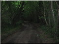
Monkery Lane in Longbeech Wood
This narrow lane leads through this large woodland. Leading from Faversham Road to A252 Canterbury Road.
Image: © David Anstiss
Taken: 28 Jun 2009
0.06 miles
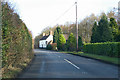
2
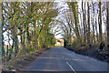
Faversham Road
Heading towards Faversham, approaching Monkery Farm.
Image: © Robin Webster
Taken: 8 Feb 2018
0.06 miles
3
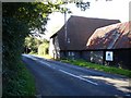
Barn at Monkery Farm
It looks like the large barn has been converted to residential accommodation.
Image: © Penny Mayes
Taken: 20 Sep 2006
0.06 miles
4
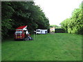
Camping at a CL
A Caravan Club Certified Location site is close by the pub. A Certified Location or CL is a site with minimum facilities and restricted to five units.
Image: © Leo
Taken: 15 Jun 2007
0.12 miles
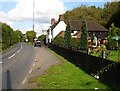
5
Faversham Road by Wagon and Horses
Heading towards Faversham.
Image: © Robin Webster
Taken: 8 Feb 2018
0.13 miles
6
The Wagon & Horses
A freehouse on the Faversham Road on the western edge of Longbeech Wood, not far from Monkery Farm.
Image: © Penny Mayes
Taken: 26 Sep 2006
0.14 miles
7
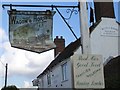
Battered pub sign
Goodness knows how this sign got bent so much out of shape. The pub http://www.geograph.org.uk/photo/249849 was being repainted and the rest of the signage looks new so perhaps it is due for replacement.
Image: © Penny Mayes
Taken: 26 Sep 2006
0.14 miles
8
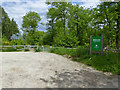
Entrance to Longbeech North Wood
A Woodland Trust property, apparently a quite recent acquisition, the generous car park and entrance gates look new. A large wood of over 100 ha.
Image: © Robin Webster
Taken: 27 May 2019
0.16 miles
9
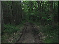
Woodland Track in Longbeech Wood
This track leads from Monkery Lane into the wood. The wood has been divided into parcels of land for sale.
Image: © David Anstiss
Taken: 28 Jun 2009
0.16 miles
10
Old Milestone by Faversham Road, Charing parish
Stone post (plate lost) by the UC road, in parish of CHARING (ASHFORD District), Faversham Road, in woodland West of Monkery Farm, at edge of woodland, on South side of road. Faversham iron plate, erected by the Biddenden to Boundgate turnpike trust in the 19th century.
Inscription once read:-
(FAVERSHAM)
(8)
(CHARING)
(2)
Carved benchmark and rivet on top.
Milestone Society National ID: KE_FVCH08.
Image: © C Woodward
Taken: 27 Feb 2012
0.19 miles