IMAGES TAKEN NEAR TO
The Moat, ASHFORD, TN27 0JJ
Introduction
This page details the photographs taken nearby to The Moat, TN27 0JJ by members of the Geograph project.
The Geograph project started in 2005 with the aim of publishing, organising and preserving representative images for every square kilometre of Great Britain, Ireland and the Isle of Man.

There are currently over 7.5m images from over14,400 individuals and you can help contribute to the project by visiting https://www.geograph.org.uk
Image Map (Loading...)


Getting Data...Please wait
Leaflet Map data © OpenStreetMap
Images are licensed for reuse under creativecommons.org/licenses/by-sa/2.0
Notes
- Clicking on the map will re-center to the selected point.
- The higher the marker number, the further away the image location is from the centre of the postcode.
Image Listing (149 Images Found)
Images are licensed for reuse under creativecommons.org/licenses/by-sa/2.0
Image
Details
Distance
1
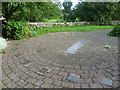
The human sundial, Charing
The human sundial is found in a small garden, just off Market Place. The idea is that the person stands with their feet on the central strip in whatever place is dictated by the time of year, and their shadow will indicate the time (by British Summer Time) on the outer circle. It certainly seemed accurate enough when I tried it.
Another example of a human sundial can be seen at Knockholt http://www.geograph.org.uk/photo/3931002
Image: © Marathon
Taken: 11 Sep 2011
0.06 miles
2
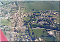
Charing, aerial view
Looking along Station Road, with the A20 Maidstone Road crossing left-right, and beyond it the High Street. The rectangular housing in right middleground is The Moat. Downs Way is the angular road with housing near top left. (date somewhat uncertain)
Image: © Peter Facey
Taken: 1 Jun 1989
0.06 miles
3
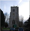
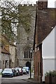
Church of St Peter and St Paul, Charing
13th century Grade I listed. http://www.britishlistedbuildings.co.uk/en-180767-church-of-st-peter-and-st-paul-charing
Image: © N Chadwick
Taken: 28 Nov 2010
0.07 miles
4

St Peter's Church, Market Place, Charing, Kent
Grade I listed.
Image: © Oast House Archive
Taken: 10 Jul 2009
0.07 miles
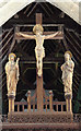
5

St Peter & St Paul, Charing, Kent - Window
Image: © John Salmon
Taken: 19 Jul 2006
0.07 miles
8
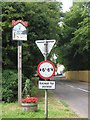
Charing Village Sign
On Old Ashford Road, leading from A20 Maidstone Road into the village.
Image: © David Anstiss
Taken: 4 Jul 2009
0.08 miles
9
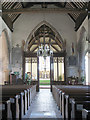
St Peter & St Paul, Charing, Kent - East end
Image: © John Salmon
Taken: 19 Jul 2006
0.08 miles
10
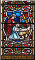
St Peter & St Paul, Charing - Stained glass window
Image: © John Salmon
Taken: 20 Apr 2015
0.08 miles