IMAGES TAKEN NEAR TO
High Street, ASHFORD, TN27 0HU
Introduction
This page details the photographs taken nearby to High Street, TN27 0HU by members of the Geograph project.
The Geograph project started in 2005 with the aim of publishing, organising and preserving representative images for every square kilometre of Great Britain, Ireland and the Isle of Man.

There are currently over 7.5m images from over14,400 individuals and you can help contribute to the project by visiting https://www.geograph.org.uk
Image Map
Images are licensed for reuse under creativecommons.org/licenses/by-sa/2.0
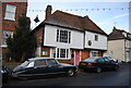
Notes
- Clicking on the map will re-center to the selected point.
- The higher the marker number, the further away the image location is from the centre of the postcode.
Image Listing (183 Images Found)
Images are licensed for reuse under creativecommons.org/licenses/by-sa/2.0
Image
Details
Distance
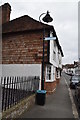
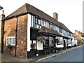
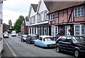
1
Cottage, High St
15th century, Grade II listed. http://www.britishlistedbuildings.co.uk/en-180727-chesnut-house-tea-rooms-19-charing
Image: © N Chadwick
Taken: 28 Nov 2010
0.00 miles
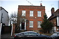
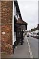
2
Chestnut House
Grade II listed. https://historicengland.org.uk/listing/the-list/list-entry/1363018
Image: © N Chadwick
Taken: 11 Apr 2019
0.00 miles
3
Peckwater House
18th century, Grade II listed. http://www.britishlistedbuildings.co.uk/en-180726-peckwater-house-17-charing
Image: © N Chadwick
Taken: 28 Nov 2010
0.01 miles
4
Ridgemont
Grade II listed. https://historicengland.org.uk/listing/the-list/list-entry/1070751
Image: © N Chadwick
Taken: 11 Apr 2019
0.01 miles
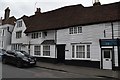
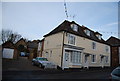
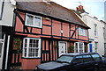
5
Sherbourne House, High Street, Charing
Sherbourne House is a mid 16th century timber framed building with shops and accommodation. It is a Grade II* listed building. https://britishlistedbuildings.co.uk/101070740-sherborne-house-charing#.W6ekPPZFw5s
Image: © G Laird
Taken: 13 Sep 2018
0.01 miles
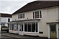
7
21 - 25 High St, Charing
18th century Grade II listed. http://www.britishlistedbuildings.co.uk/en-180728-21-23-and-25-charing , formerly the old bakery.
Image: © N Chadwick
Taken: 28 Nov 2010
0.02 miles
8
Bookmakers Arms
Grade II listed. https://historicengland.org.uk/listing/the-list/list-entry/1185793
Image: © N Chadwick
Taken: 11 Apr 2019
0.02 miles
9
The High Street, Charing
Southern end of The High Street showing the junction with the A20 Maidstone Road and Station Road.
Image: © Penny Mayes
Taken: 3 Aug 2005
0.02 miles
10
Cottage, High St
16th century Grade II listed. http://www.britishlistedbuildings.co.uk/en-180724-9-charing
Image: © N Chadwick
Taken: 28 Nov 2010
0.02 miles