IMAGES TAKEN NEAR TO
Bowl Road, ASHFORD, TN27 0HB
Introduction
This page details the photographs taken nearby to Bowl Road, TN27 0HB by members of the Geograph project.
The Geograph project started in 2005 with the aim of publishing, organising and preserving representative images for every square kilometre of Great Britain, Ireland and the Isle of Man.

There are currently over 7.5m images from over14,400 individuals and you can help contribute to the project by visiting https://www.geograph.org.uk
Image Map (Loading...)


Getting Data...Please wait
Leaflet Map data © OpenStreetMap
Images are licensed for reuse under creativecommons.org/licenses/by-sa/2.0
Notes
- Clicking on the map will re-center to the selected point.
- The higher the marker number, the further away the image location is from the centre of the postcode.
Image Listing (15 Images Found)
Images are licensed for reuse under creativecommons.org/licenses/by-sa/2.0
Image
Details
Distance
1
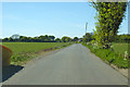
Bowl Road north from Charing Hill
An Ancient Trackway according to the map, but it seems undistinguished now.
Image: © Robin Webster
Taken: 14 May 2019
0.06 miles
2
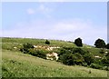
Disused Quarry near Charing
This deep quarry, has a hidden surprise. Several cows were sheltering in the scorning summer heat in this abandoned quarry. The village of Charing is in the background.
Image: © David Anstiss
Taken: 28 Jun 2009
0.15 miles
3

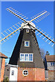
Charing Windmill
Perched on the top of the North Downs
Image: © Paul
Taken: 21 Apr 2009
0.16 miles
4
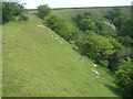
Footpath past a disused quarry
This footpath leads from the North Downs Way (long distance path) in Charing Hill, to Bowl Road.
Image: © David Anstiss
Taken: 28 Jun 2009
0.19 miles
5
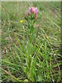
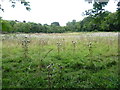
Common Centaury in disused Quarry near Charing
This is Centaurium Erythraea. This lovely little plant was growing in the grass meadows of the quarry.
Image: © David Anstiss
Taken: 28 Jun 2009
0.19 miles
6
Windmill at Charing
Windmill overlooking Charing, Kent.
Image: © Wayland Smith
Taken: 3 Feb 2019
0.20 miles
7
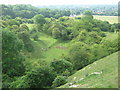
Old quarries near Charing Hill
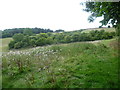
Seen from the North Downs Way, these old chalk quarries are being reclaimed by nature. A footpath runs through the middle of them.
Image: © Marathon
Taken: 1 Sep 2013
0.21 miles
8
Part of disused quarry, Charing Hill
Taken from North Downs Way.
Image: © David Kemp
Taken: 22 Jun 2006
0.21 miles
9
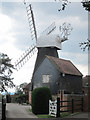
Charing Mill
Grade II listed http://list.english-heritage.org.uk/resultsingle.aspx?uid=1299636 smock mill.
Image: © Oast House Archive
Taken: 19 Aug 2011
0.21 miles
10
Former chalk quarries near Charing Hill
Seen from near the North Downs Way, these old chalk quarries are being reclaimed by nature. A footpath runs from here through the middle of them.
Image: © Marathon
Taken: 1 Sep 2013
0.21 miles