IMAGES TAKEN NEAR TO
Canterbury Road, ASHFORD, TN27 0EY
Introduction
This page details the photographs taken nearby to Canterbury Road, TN27 0EY by members of the Geograph project.
The Geograph project started in 2005 with the aim of publishing, organising and preserving representative images for every square kilometre of Great Britain, Ireland and the Isle of Man.

There are currently over 7.5m images from over14,400 individuals and you can help contribute to the project by visiting https://www.geograph.org.uk
Image Map (Loading...)


Getting Data...Please wait
Leaflet Map data © OpenStreetMap
Images are licensed for reuse under creativecommons.org/licenses/by-sa/2.0
Notes
- Clicking on the map will re-center to the selected point.
- The higher the marker number, the further away the image location is from the centre of the postcode.
Image Listing (9 Images Found)
Images are licensed for reuse under creativecommons.org/licenses/by-sa/2.0
Image
Details
Distance
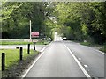
1
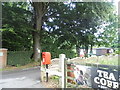
The entrance to Longbeech Park, Charing Hill
Image: © David Howard
Taken: 12 Jun 2016
0.02 miles
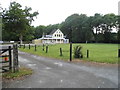
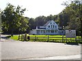
2
The entrance to Longbeech Park on Canterbury Road
This is a static caravan park
Image: © David Howard
Taken: 12 Jun 2016
0.03 miles
4
Mehfil Indian Restaurant on Canterbury Road
Image: © David Howard
Taken: 12 Jun 2016
0.05 miles
6
Country Style Indian Restaurant
On the A252 Canterbury Road as it cuts through Longbeech Wood on the Downs above Charing. Indian food must be popular hereabouts, this is about 1 kilometre from Image and is sited next to a chalet park.
Image: © Penny Mayes
Taken: 20 Sep 2006
0.09 miles
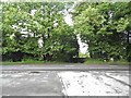
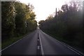
7
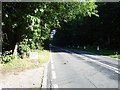
A252 through Longbeech Wood
A remarkably straight (but far from flat) stretch of road which cuts through Longbeech Wood, a huge area of woodland on top of the North Downs above Charing, classified by the Forestry Commission as a plantation on an Ancient Woodland Site.
Image: © Penny Mayes
Taken: 20 Sep 2006
0.10 miles
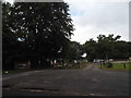
8
Canterbury Road east of Charing
Looking at the map this is almost certainly a Roman road.
Image: © David Howard
Taken: 12 Jun 2016
0.15 miles
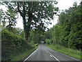
9
The A252 Canterbury towards Charing
This long straight road leads from Challock towards Charing Hill. Several hollows along the road, make it dangerous to overtake slow moving traffic. It also passes through Longbeech Wood.
Image: © David Anstiss
Taken: 17 Oct 2009
0.25 miles