IMAGES TAKEN NEAR TO
Calehill Road, ASHFORD, TN27 0ES
Introduction
This page details the photographs taken nearby to Calehill Road, TN27 0ES by members of the Geograph project.
The Geograph project started in 2005 with the aim of publishing, organising and preserving representative images for every square kilometre of Great Britain, Ireland and the Isle of Man.

There are currently over 7.5m images from over14,400 individuals and you can help contribute to the project by visiting https://www.geograph.org.uk
Image Map (Loading...)


Getting Data...Please wait
Leaflet Map data © OpenStreetMap
Images are licensed for reuse under creativecommons.org/licenses/by-sa/2.0
Notes
- Clicking on the map will re-center to the selected point.
- The higher the marker number, the further away the image location is from the centre of the postcode.
Image Listing (7 Images Found)
Images are licensed for reuse under creativecommons.org/licenses/by-sa/2.0
Image
Details
Distance
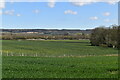
5
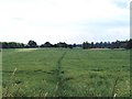
Field of oilseed rape near Little Chart
Although the gridsquare is dominated by the M20 and the Channel Tunnel Rail Link, most of it comprises open farmland such as this. The track through the middle of the field is a public footpath leading to the entrance to Calehill Park Image Taken from beside the M20.
Image: © David Kemp
Taken: 27 Jun 2006
0.23 miles