IMAGES TAKEN NEAR TO
Hurstford Lane, ASHFORD, TN27 0ER
Introduction
This page details the photographs taken nearby to Hurstford Lane, TN27 0ER by members of the Geograph project.
The Geograph project started in 2005 with the aim of publishing, organising and preserving representative images for every square kilometre of Great Britain, Ireland and the Isle of Man.

There are currently over 7.5m images from over14,400 individuals and you can help contribute to the project by visiting https://www.geograph.org.uk
Image Map (Loading...)


Getting Data...Please wait
Leaflet Map data © OpenStreetMap
Images are licensed for reuse under creativecommons.org/licenses/by-sa/2.0
Notes
- Clicking on the map will re-center to the selected point.
- The higher the marker number, the further away the image location is from the centre of the postcode.
Image Listing (5 Images Found)
Images are licensed for reuse under creativecommons.org/licenses/by-sa/2.0
Image
Details
Distance
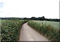
3
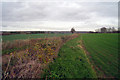
Hedgerow along Hurstford Lane
Between the lane and a crop field. Part of the Greensand Way runs along Hurstford Lane.
Image: © Oast House Archive
Taken: 1 Dec 2009
0.19 miles
4
Single track lane between Westwell Leacon and Little Chart
This lane forms a part of the Greensand Way footpath.
Image: © David Kemp
Taken: 26 Jun 2006
0.19 miles