IMAGES TAKEN NEAR TO
Bethersden, ASHFORD, TN26 3JY
Introduction
This page details the photographs taken nearby to TN26 3JY by members of the Geograph project.
The Geograph project started in 2005 with the aim of publishing, organising and preserving representative images for every square kilometre of Great Britain, Ireland and the Isle of Man.

There are currently over 7.5m images from over14,400 individuals and you can help contribute to the project by visiting https://www.geograph.org.uk
Image Map
Images are licensed for reuse under creativecommons.org/licenses/by-sa/2.0
Notes
- Clicking on the map will re-center to the selected point.
- The higher the marker number, the further away the image location is from the centre of the postcode.
Image Listing (12 Images Found)
Images are licensed for reuse under creativecommons.org/licenses/by-sa/2.0
Image
Details
Distance
1
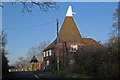
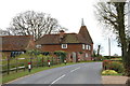
High Oak Oast, Woodchurch Road, Bethersden, Kent
Single round kiln oast house.
Image: © Oast House Archive
Taken: 26 Nov 2009
0.02 miles
2
High Oak Oast, Woodchurch Road, Bethersden, Kent
Single round kiln oast house.
Image: © Oast House Archive
Taken: 26 Nov 2009
0.02 miles
3
High Oak Oast, Woodchurch Road, Bethersden, Kent
Single round kiln oast house.
Image: © Oast House Archive
Taken: 3 May 2008
0.03 miles
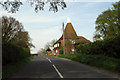
4
High Oak Oast on Woodchurch Road
Pseudo HDR Image.
Image: © Julian P Guffogg
Taken: 21 Apr 2012
0.03 miles
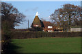
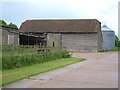
6
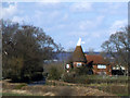
Former Oast house at High Oak Farm
Viewed from the south. See Image for a closer view.
Image: © Stephen Craven
Taken: 11 Apr 2015
0.03 miles
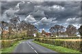
7
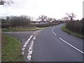
Lane junction on Bethersden Road
Bethersden Road leads from the A28 Ashford Road towards Shirkoak and Woodchurch.
The lane on the left is unnamed, but leads past Rainford House and Ruck Wood, towards Plurenden Road. In the background is High Oak Farm.
Image: © David Anstiss
Taken: 24 Jan 2010
0.10 miles
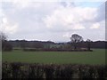
8
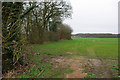
Field corner
The scrap of woodland on the left contains a pond or flooded pit, but too overgrown to view properly.
Image: © Robin Webster
Taken: 21 Mar 2010
0.14 miles
9
Barn at Vine Hall
Seen from the lane south of Brissenden Green.
Image: © Derek Harper
Taken: 21 May 2006
0.20 miles
10
View from Bethersden Road
Looking towards the A28 Ashford Road, between Furner Wood (on the right) and Beak Wood (on the left). Beyond the A28 is Wetlands Wood.
Image: © David Anstiss
Taken: 24 Jan 2010
0.22 miles