IMAGES TAKEN NEAR TO
Redbrook Street, ASHFORD, TN26 3JH
Introduction
This page details the photographs taken nearby to Redbrook Street, TN26 3JH by members of the Geograph project.
The Geograph project started in 2005 with the aim of publishing, organising and preserving representative images for every square kilometre of Great Britain, Ireland and the Isle of Man.

There are currently over 7.5m images from over14,400 individuals and you can help contribute to the project by visiting https://www.geograph.org.uk
Image Map
Images are licensed for reuse under creativecommons.org/licenses/by-sa/2.0
Notes
- Clicking on the map will re-center to the selected point.
- The higher the marker number, the further away the image location is from the centre of the postcode.
Image Listing (11 Images Found)
Images are licensed for reuse under creativecommons.org/licenses/by-sa/2.0
Image
Details
Distance
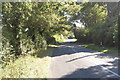
1
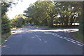
Crossroads on Plurenden Road
Redbrook Street crosses.
Image: © Julian P Guffogg
Taken: 9 Sep 2012
0.07 miles
2
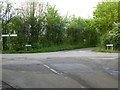
Cuckolds Corner
The intersection of Plurenden Road and Redbrook Street. There must be a story behind the name.
Image: © Oliver Dixon
Taken: 10 May 2016
0.07 miles
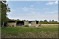
5
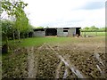
Muddy field and makeshift stable
Off Plurenden Road.
Image: © Oliver Dixon
Taken: 10 May 2016
0.12 miles
9
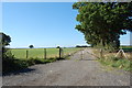
Course of Old roman Road off Redbrook Street
Now a Farm Track.
Image: © Julian P Guffogg
Taken: 9 Sep 2012
0.18 miles