IMAGES TAKEN NEAR TO
Bethersden, ASHFORD, TN26 3DX
Introduction
This page details the photographs taken nearby to TN26 3DX by members of the Geograph project.
The Geograph project started in 2005 with the aim of publishing, organising and preserving representative images for every square kilometre of Great Britain, Ireland and the Isle of Man.

There are currently over 7.5m images from over14,400 individuals and you can help contribute to the project by visiting https://www.geograph.org.uk
Image Map
Images are licensed for reuse under creativecommons.org/licenses/by-sa/2.0
Notes
- Clicking on the map will re-center to the selected point.
- The higher the marker number, the further away the image location is from the centre of the postcode.
Image Listing (20 Images Found)
Images are licensed for reuse under creativecommons.org/licenses/by-sa/2.0
Image
Details
Distance
1
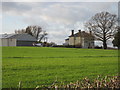
Frid Farm
With Robin DR400 plane outside.
Image: © Julian P Guffogg
Taken: 8 Dec 2013
0.01 miles
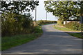
3
Frid Farm
Boasts its own aeroplane and landing strip
Image: © Geoff Gartside
Taken: 15 Apr 2007
0.05 miles

5
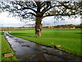
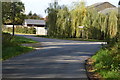
Driveway to Frid Farm
The driveway is also followed by a footpath. After following the very wet and muddy path to reach the farm from the south - see http://www.geograph.org.uk/photo/4247896 - this driveway was quite a relief.
Image: © Marathon
Taken: 15 Nov 2014
0.06 miles
7
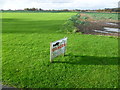
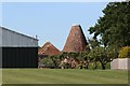
Private aircraft landing strip
This is real oneupmanship. Having your own swimming pool or horses is quite impressive but not many properties have their own private aircraft landing strip. The aeroplane is kept in a large shed at Frid Farm.
Image: © Marathon
Taken: 15 Nov 2014
0.11 miles
9
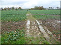
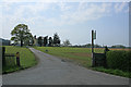
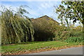
Footpath to Frid Farm - wellingtons required
After a day of heavy rain, all the fields and paths were either under water or at best very muddy. Wellington boots were a minimum requirement. Here the path heads across a field from Frid Wood to reach Frid Farm ahead to the right.
Image: © Marathon
Taken: 15 Nov 2014
0.13 miles