IMAGES TAKEN NEAR TO
Pluckley Road, ASHFORD, TN26 3DD
Introduction
This page details the photographs taken nearby to Pluckley Road, TN26 3DD by members of the Geograph project.
The Geograph project started in 2005 with the aim of publishing, organising and preserving representative images for every square kilometre of Great Britain, Ireland and the Isle of Man.

There are currently over 7.5m images from over14,400 individuals and you can help contribute to the project by visiting https://www.geograph.org.uk
Image Map
Images are licensed for reuse under creativecommons.org/licenses/by-sa/2.0
Notes
- Clicking on the map will re-center to the selected point.
- The higher the marker number, the further away the image location is from the centre of the postcode.
Image Listing (24 Images Found)
Images are licensed for reuse under creativecommons.org/licenses/by-sa/2.0
Image
Details
Distance
1
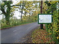
Pluckley Road
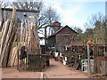
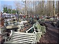
This is Pluckley Road on a damp autumn afternoon. Photographs in Symonds Salvage Yard can be seen at http://www.geograph.org.uk/photo/3886806 and http://www.geograph.org.uk/photo/3886807
Image: © Marathon
Taken: 15 Nov 2014
0.05 miles
2
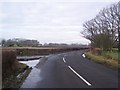
Junction on Pluckley Road
Pluckley Road leads from Bethersden straight on towards Pluckley. Norton Lane leads left past Bethersden towards Wissenden Lane. New Barn Farm is in the background.
Image: © David Anstiss
Taken: 24 Jan 2010
0.07 miles
3
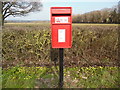
New Post Box in Pluckley Road, Bethersden
This photo shows a new post box in Pluckley Road with the wording "ROYAL MAIL" inscribed above the slot and the modern EIIR insignia below it. According to the notice on its door, this box has a last collection time of 9.00am on Monday to Friday and 7.00am on Saturday.
Image: © David Hillas
Taken: 17 Mar 2016
0.07 miles
4
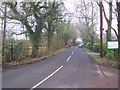
Pluckley Road
This road leads from Bethersden towards Pluckley.
Image: © David Anstiss
Taken: 24 Jan 2010
0.08 miles
6
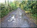
Track to Frid Wood
After a day of heavy rain, all the fields and paths were either under water or at best very muddy. This track leads from Pluckley Road to Frid Wood and passes Symonds Salvage Yard just ahead - see http://www.geograph.org.uk/photo/3886806 and http://www.geograph.org.uk/photo/3886807
Image: © Marathon
Taken: 15 Nov 2014
0.10 miles
7
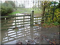
A very wet footpath
This view is from Pluckley Road looking along the footpath to Bethersden Churchyard. After a day of heavy rain, all the fields were either under water or at best very muddy. Wellington boots were a minimum requirement.
Image: © Marathon
Taken: 15 Nov 2014
0.10 miles

10
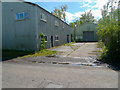
Disused Colt Homes factory and Saw Mill
This is the disused factory has been silent for many years and an eyesore.
Image: © Peter Skynner
Taken: 1 May 2020
0.12 miles