IMAGES TAKEN NEAR TO
Ashford Road, ASHFORD, TN26 3AT
Introduction
This page details the photographs taken nearby to Ashford Road, TN26 3AT by members of the Geograph project.
The Geograph project started in 2005 with the aim of publishing, organising and preserving representative images for every square kilometre of Great Britain, Ireland and the Isle of Man.

There are currently over 7.5m images from over14,400 individuals and you can help contribute to the project by visiting https://www.geograph.org.uk
Image Map
Images are licensed for reuse under creativecommons.org/licenses/by-sa/2.0
Notes
- Clicking on the map will re-center to the selected point.
- The higher the marker number, the further away the image location is from the centre of the postcode.
Image Listing (27 Images Found)
Images are licensed for reuse under creativecommons.org/licenses/by-sa/2.0
Image
Details
Distance
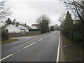
1
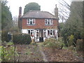
Rose Cottage
On the A28 Ashford Road near Bethersden.
Image: © David Anstiss
Taken: 21 Feb 2010
0.02 miles
2
Big Tree Farm
On the A28 Ashford Road.
Image: © David Anstiss
Taken: 21 Feb 2010
0.11 miles
3
A28 Ashford Road and Kiln Lane Junction
This road leads from Bethersden to Ashford. Kiln Lane leads left to Old Surrenden Manor Road.
Image: © David Anstiss
Taken: 21 Feb 2010
0.17 miles
4
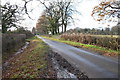
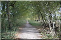
Kiln Lane
Towards the A28, near Bethersden.
Image: © Julian P Guffogg
Taken: 9 Dec 2013
0.18 miles
5
Junction on A28
A reverse view of Image, with Kiln Lane leaving on the right.
Image: © Derek Harper
Taken: 21 May 2006
0.18 miles
6
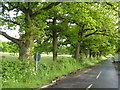
Kiln Lane, Bethersden
Looking up this oak tree-lined lane from the A28 junction.
Image: © Derek Harper
Taken: 21 May 2006
0.20 miles
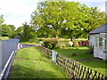
8
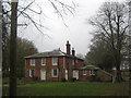
Thorne Lodge and entrance to the Thorne Estate
On Forge Hill.
Image: © David Anstiss
Taken: 21 Feb 2010
0.21 miles