IMAGES TAKEN NEAR TO
Ruckinge, ASHFORD, TN26 2QD
Introduction
This page details the photographs taken nearby to TN26 2QD by members of the Geograph project.
The Geograph project started in 2005 with the aim of publishing, organising and preserving representative images for every square kilometre of Great Britain, Ireland and the Isle of Man.

There are currently over 7.5m images from over14,400 individuals and you can help contribute to the project by visiting https://www.geograph.org.uk
Image Map
Images are licensed for reuse under creativecommons.org/licenses/by-sa/2.0
Notes
- Clicking on the map will re-center to the selected point.
- The higher the marker number, the further away the image location is from the centre of the postcode.
Image Listing (18 Images Found)
Images are licensed for reuse under creativecommons.org/licenses/by-sa/2.0
Image
Details
Distance


3
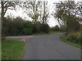
Footpath junction near Hill's Farm
Newchurch Lane leads (from Newchurch) right towards Image, and then onwards to Poplar Farm near Ivychurch. Frostland Lane leads left towards Squires Farm and Norwood Farm.
Image: © David Anstiss
Taken: 7 Nov 2010
0.07 miles
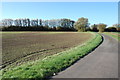


9
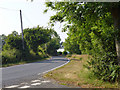
Newchurch Lane
By the Frostland Lane corner.
Image: © Robin Webster
Taken: 13 Jul 2013
0.14 miles
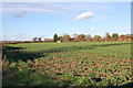
10
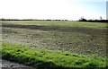
Green Shoots
Field off Frostland Lane on Romney Marsh.
Image: © Julian P Guffogg
Taken: 27 Oct 2012
0.15 miles