IMAGES TAKEN NEAR TO
Ruckinge, ASHFORD, TN26 2PR
Introduction
This page details the photographs taken nearby to TN26 2PR by members of the Geograph project.
The Geograph project started in 2005 with the aim of publishing, organising and preserving representative images for every square kilometre of Great Britain, Ireland and the Isle of Man.

There are currently over 7.5m images from over14,400 individuals and you can help contribute to the project by visiting https://www.geograph.org.uk
Image Map (Loading...)


Getting Data...Please wait
Leaflet Map data © OpenStreetMap
Images are licensed for reuse under creativecommons.org/licenses/by-sa/2.0
Notes
- Clicking on the map will re-center to the selected point.
- The higher the marker number, the further away the image location is from the centre of the postcode.
Image Listing (8 Images Found)
Images are licensed for reuse under creativecommons.org/licenses/by-sa/2.0
Image
Details
Distance
1
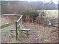
Footpath junction near Roughstocks Wood (2)
The Greensand Way (long distance path) heads from Poundhurst Road towards the wood and then onto Capel Road. Crossing it a path heads right towards Ash Hill near Stonegate Farm, or left to Poundhurst Road near Hollybush Farm.
Image: © David Anstiss
Taken: 21 Feb 2010
0.14 miles
2
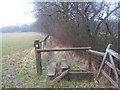
Two step stile on Greensand Way
The long distance path heads towards Poundhurst Road from Roughstocks Wood and Capel Road.
Image: © David Anstiss
Taken: 21 Feb 2010
0.14 miles
3
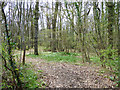
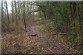
Roughstocks Wood
Wood Anemone is well out.
Image: © Robin Webster
Taken: 28 Mar 2017
0.15 miles
4
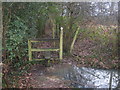
Stile on Greensand Way near Roughstocks Wood
The long distance path heads from Capel Road towards Poundhurst Road.
Image: © David Anstiss
Taken: 21 Feb 2010
0.16 miles
5
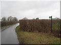
The Greensand Way on Poundhurst Road
The long distance path heads right towards Roughstocks Wood and Capel Road. It also heads along the lane towards Gill Lane.
Image: © David Anstiss
Taken: 21 Feb 2010
0.20 miles
6
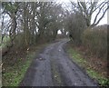
Byway from Hodge's Wood
This track is a byway from the wood towards Ash Hill.
Image: © David Anstiss
Taken: 21 Feb 2010
0.22 miles
7
The Greensand Way near Roughstocks Wood
The long distance path heads from Poundhurst Road towards Capel Road. It crosses over a series of bumps on the footpath.
Image: © David Anstiss
Taken: 21 Feb 2010
0.23 miles
8
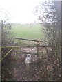
Stile on the Saxon Shore
This is on the long distance path as it leaves a byway from Hodge's Wood. The path heads across a field towards Ash Hill.
Horton Green House should be visible in the background when not so damp!!
Image: © David Anstiss
Taken: 21 Feb 2010
0.24 miles