IMAGES TAKEN NEAR TO
Ruckinge, ASHFORD, TN26 2PE
Introduction
This page details the photographs taken nearby to TN26 2PE by members of the Geograph project.
The Geograph project started in 2005 with the aim of publishing, organising and preserving representative images for every square kilometre of Great Britain, Ireland and the Isle of Man.

There are currently over 7.5m images from over14,400 individuals and you can help contribute to the project by visiting https://www.geograph.org.uk
Image Map
Images are licensed for reuse under creativecommons.org/licenses/by-sa/2.0
Notes
- Clicking on the map will re-center to the selected point.
- The higher the marker number, the further away the image location is from the centre of the postcode.
Image Listing (5 Images Found)
Images are licensed for reuse under creativecommons.org/licenses/by-sa/2.0
Image
Details
Distance
1
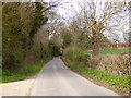
Ash Hill
Heading north from Ruckinge.
Image: © Robin Webster
Taken: 28 Mar 2017
0.12 miles
2
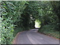
Ash Hill
Lane leading to the B2067 Hamstreet Road at Ruckinge.
Image: © Oast House Archive
Taken: 3 Jul 2010
0.16 miles
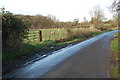
4
Footpath to Weston's Wood
A path leads from Turves Farm, Ruckinge along a hedge towards Weston's Wood in the background.
Image: © David Anstiss
Taken: 21 Feb 2010
0.23 miles
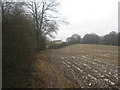
5
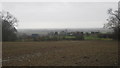
View from footpath near Turves Farm
Looking eastwards over the cottages of Ruckinge on the B2067. Towards the flat Romney Marshes.
Image: © David Anstiss
Taken: 21 Feb 2010
0.23 miles