IMAGES TAKEN NEAR TO
Kenardington, ASHFORD, TN26 2NF
Introduction
This page details the photographs taken nearby to TN26 2NF by members of the Geograph project.
The Geograph project started in 2005 with the aim of publishing, organising and preserving representative images for every square kilometre of Great Britain, Ireland and the Isle of Man.

There are currently over 7.5m images from over14,400 individuals and you can help contribute to the project by visiting https://www.geograph.org.uk
Image Map (Loading...)


Getting Data...Please wait
Leaflet Map data © OpenStreetMap
Images are licensed for reuse under creativecommons.org/licenses/by-sa/2.0
Notes
- Clicking on the map will re-center to the selected point.
- The higher the marker number, the further away the image location is from the centre of the postcode.
Image Listing (9 Images Found)
Images are licensed for reuse under creativecommons.org/licenses/by-sa/2.0
Image
Details
Distance
1
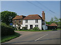
Sly Corner
Grade II listed https://www.historicengland.org.uk/listing/the-list/list-entry/1116474
Image: © Oast House Archive
Taken: 12 May 2016
0.08 miles
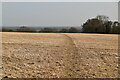
2
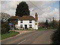
Sly Corner Cottages
Kenardington Road heads towards Kenardington. On the left, Great Heron Wood lane (unsuitable for motor vehicles) heads through Great Heron Wood to Appledore Road.
Image: © David Anstiss
Taken: 5 Apr 2010
0.09 miles
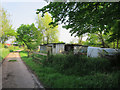
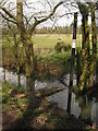
4
Muddy byway near Rushfield Wood
This byway leads from Smith's Farm towards Kenardington Road.
Image: © David Anstiss
Taken: 5 Apr 2010
0.10 miles
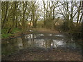
6
Broken footbridge near Sly Corner
This bridge should be on a footpath from Great Heron Wood Lane through a field towards Pond Wood and then to Appledore Road.
Image: © David Anstiss
Taken: 5 Apr 2010
0.14 miles
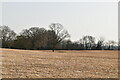
8
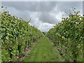
Gusbourne Vineyard
Vines of chardonnay grapes in the Gusbourne Vineyard, near Appledore, Kent.
Image: © Ajay Tegala
Taken: 8 Sep 2024
0.22 miles