IMAGES TAKEN NEAR TO
Kenardington, ASHFORD, TN26 2NE
Introduction
This page details the photographs taken nearby to TN26 2NE by members of the Geograph project.
The Geograph project started in 2005 with the aim of publishing, organising and preserving representative images for every square kilometre of Great Britain, Ireland and the Isle of Man.

There are currently over 7.5m images from over14,400 individuals and you can help contribute to the project by visiting https://www.geograph.org.uk
Image Map (Loading...)


Getting Data...Please wait
Leaflet Map data © OpenStreetMap
Images are licensed for reuse under creativecommons.org/licenses/by-sa/2.0
Notes
- Clicking on the map will re-center to the selected point.
- The higher the marker number, the further away the image location is from the centre of the postcode.
Image Listing (20 Images Found)
Images are licensed for reuse under creativecommons.org/licenses/by-sa/2.0
Image
Details
Distance
2
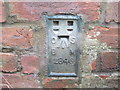
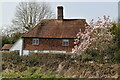
Ordnance Survey Flush Bracket 2846
This can be found on the roadside wall of a house at Manor Farm.
For more detail see : http://www.bench-marks.org.uk/bm11994
Image: © Peter Wood
Taken: 13 Feb 2016
0.01 miles
3
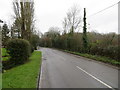
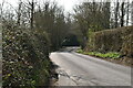
Road at Manor Farm
Looking south-westward in the direction of Sly Corner.
Image: © Peter Wood
Taken: 13 Feb 2016
0.01 miles