IMAGES TAKEN NEAR TO
Appledore Road, ASHFORD, TN26 2LZ
Introduction
This page details the photographs taken nearby to Appledore Road, TN26 2LZ by members of the Geograph project.
The Geograph project started in 2005 with the aim of publishing, organising and preserving representative images for every square kilometre of Great Britain, Ireland and the Isle of Man.

There are currently over 7.5m images from over14,400 individuals and you can help contribute to the project by visiting https://www.geograph.org.uk
Image Map (Loading...)


Getting Data...Please wait
Leaflet Map data © OpenStreetMap
Images are licensed for reuse under creativecommons.org/licenses/by-sa/2.0
Notes
- Clicking on the map will re-center to the selected point.
- The higher the marker number, the further away the image location is from the centre of the postcode.
Image Listing (35 Images Found)
Images are licensed for reuse under creativecommons.org/licenses/by-sa/2.0
Image
Details
Distance
1
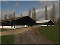
Poultry Houses in Horsemarsh Farm
These large sheds are beside a footpath towards Kenardington.
Image: © David Anstiss
Taken: 5 Apr 2010
0.08 miles
2
Entrance off Kenardington Road, Kenardington, Kent
Image: © Oast House Archive
Taken: 7 Oct 2008
0.10 miles
3
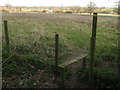
Stile and footpath junction near Horsemarsh Farm
This stile is on the edge of Horsemarsh Farm, a path leads straight on towards the B2067 near World's Wonder Public house (white building in the background). Another path heads right towards Warehorne past Stone Farm.
Image: © David Anstiss
Taken: 5 Apr 2010
0.12 miles
4

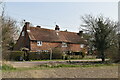
High House Farmhouse
On Kenardington Road.
Image: © David Anstiss
Taken: 5 Apr 2010
0.12 miles
5
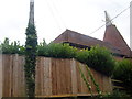
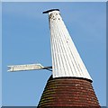
Kenardington, High House Oast
Kenardington, Warehorne Street, B2067, High House Oast.
Image: © Helmut Zozmann
Taken: 30 Jul 2009
0.15 miles
6
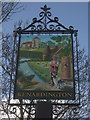
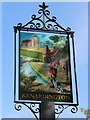
Close-up of Kenardington Village Sign
Close-up of Image
It shows St Mary's Church (see Image) , the Royal Military Canal (see http://www.geograph.org.uk/snippet/7570 - for more photos of the canal) and a double Oast House. (Although both Oast Houses in the village have only one round Oast!) See (Image) and (Image).
See also http://en.wikipedia.org/wiki/Kenardington for details about the village.
Image: © David Anstiss
Taken: 5 Apr 2010
0.16 miles
7

Kenardington Village Sign
On the junction of Kenardington Road and the B2067 (on the right).
Image: © David Anstiss
Taken: 5 Apr 2010
0.16 miles