IMAGES TAKEN NEAR TO
Hardens View, ASHFORD, TN26 2LG
Introduction
This page details the photographs taken nearby to Hardens View, TN26 2LG by members of the Geograph project.
The Geograph project started in 2005 with the aim of publishing, organising and preserving representative images for every square kilometre of Great Britain, Ireland and the Isle of Man.

There are currently over 7.5m images from over14,400 individuals and you can help contribute to the project by visiting https://www.geograph.org.uk
Image Map (42 Images)


Leaflet Map data © OpenStreetMap
Images are licensed for reuse under creativecommons.org/licenses/by-sa/2.0
Notes
- Clicking on the map will re-center to the selected point.
- The higher the marker number, the further away the image location is from the centre of the postcode.
Image Listing (42 Images Found)
Images are licensed for reuse under creativecommons.org/licenses/by-sa/2.0
Image
Details
Distance
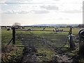
2
Warehorne Village Hall
On Church Lane.
Image: © David Anstiss
Taken: 29 Aug 2010
0.06 miles
3
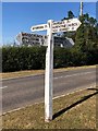
Direction Sign ? Signpost
Located on a grass triangle on the south side of the crossroads of the B2067 and Church Road in The Leacon in Warehorne parish. 4 arms and no finial.
Milestone Society National ID: KE_TQ9832
Image: © M Chamberlain
Taken: 22 Sep 2019
0.09 miles
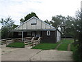
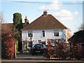
4
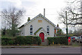
Providence Chapel 1866
On the B2067, Warehorne.
Image: © Robin Webster
Taken: 16 Feb 2007
0.10 miles
5
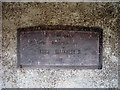
Queen Elizabeth II Coronation Plaque
Seen in Image
Image: © Oast House Archive
Taken: 8 Oct 2009
0.10 miles
6
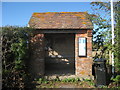
Bus Shelter at The Leacon
A plaque in side says the bus shelter commemorates Queen Elizabeth II coronation in 1955.
Image
Image: © Oast House Archive
Taken: 8 Oct 2009
0.10 miles
8
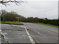
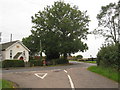
Road (B2067) at its junction with the lane to Warhorne
Looking south-westward.
Image: © Peter Wood
Taken: 13 Feb 2016
0.10 miles
10
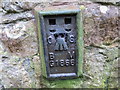
Ordnance Survey Flush Bracket G1866
This can be found on the wall of a former chapel - now a private dwelling - beside the B2067 near Warehorn.
For more detail see : http://www.bench-marks.org.uk/bm14987
Image: © Peter Wood
Taken: 13 Feb 2016
0.11 miles