IMAGES TAKEN NEAR TO
Warehorne Road, ASHFORD, TN26 2JY
Introduction
This page details the photographs taken nearby to Warehorne Road, TN26 2JY by members of the Geograph project.
The Geograph project started in 2005 with the aim of publishing, organising and preserving representative images for every square kilometre of Great Britain, Ireland and the Isle of Man.

There are currently over 7.5m images from over14,400 individuals and you can help contribute to the project by visiting https://www.geograph.org.uk
Image Map (Loading...)


Getting Data...Please wait
Leaflet Map data © OpenStreetMap
Images are licensed for reuse under creativecommons.org/licenses/by-sa/2.0
Notes
- Clicking on the map will re-center to the selected point.
- The higher the marker number, the further away the image location is from the centre of the postcode.
Image Listing (173 Images Found)
Images are licensed for reuse under creativecommons.org/licenses/by-sa/2.0
Image
Details
Distance
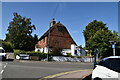
1
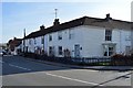
House on Ashford Road, Hamstreet, Kent
Grade II listed.
Also see Image
Image: © Oast House Archive
Taken: 29 May 2009
0.01 miles
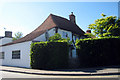
2
Wealden Hall House on Ashford Road, Hamstreet, Kent
Grade II listed.
Image: © Oast House Archive
Taken: 4 Jul 2009
0.01 miles
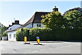
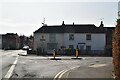
5
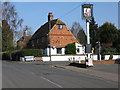
Old Eastside, on junction of Ruckinge Road and The Street
On the opposite side of Ruckinge Road to The Dukes Head, the sign of which can be seen on the corner.
Image: © Nick Smith
Taken: 16 Mar 2009
0.01 miles
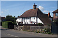
9
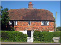
Old Eastside, Ashford Road
Early C18 Grade II listed house.
Image: © Oast House Archive
Taken: 29 May 2009
0.02 miles