IMAGES TAKEN NEAR TO
Bromley Green Road, ASHFORD, TN26 2EQ
Introduction
This page details the photographs taken nearby to Bromley Green Road, TN26 2EQ by members of the Geograph project.
The Geograph project started in 2005 with the aim of publishing, organising and preserving representative images for every square kilometre of Great Britain, Ireland and the Isle of Man.

There are currently over 7.5m images from over14,400 individuals and you can help contribute to the project by visiting https://www.geograph.org.uk
Image Map
Images are licensed for reuse under creativecommons.org/licenses/by-sa/2.0
Notes
- Clicking on the map will re-center to the selected point.
- The higher the marker number, the further away the image location is from the centre of the postcode.
Image Listing (6 Images Found)
Images are licensed for reuse under creativecommons.org/licenses/by-sa/2.0
Image
Details
Distance
2
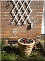
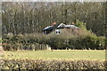
Surveyors datum mark
This surveyors mark cut into the brickwork on the cottage in Bromley Green Road was used to set up a theodolite for measuring levels, this one which is at 152.55 feet above sea level was used in setting out the main drainage scheme going into Ashford
Image: © D-G-Seamon
Taken: 4 Apr 2007
0.17 miles
4
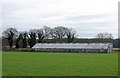
Disused Greenhouses, Bromley Green
The right hand end juts into TQ9936.
Image: © Robin Webster
Taken: 16 Feb 2007
0.21 miles