IMAGES TAKEN NEAR TO
Bromley Green Road, ASHFORD, TN26 2EE
Introduction
This page details the photographs taken nearby to Bromley Green Road, TN26 2EE by members of the Geograph project.
The Geograph project started in 2005 with the aim of publishing, organising and preserving representative images for every square kilometre of Great Britain, Ireland and the Isle of Man.

There are currently over 7.5m images from over14,400 individuals and you can help contribute to the project by visiting https://www.geograph.org.uk
Image Map
Images are licensed for reuse under creativecommons.org/licenses/by-sa/2.0
Notes
- Clicking on the map will re-center to the selected point.
- The higher the marker number, the further away the image location is from the centre of the postcode.
Image Listing (8 Images Found)
Images are licensed for reuse under creativecommons.org/licenses/by-sa/2.0
Image
Details
Distance
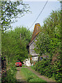
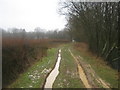
1
Bromley Green Road
From 90° bend, adjacent byway to Harding's Bridge.
Image: © Oast House Archive
Taken: 3 Jul 2010
0.02 miles
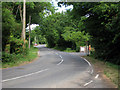
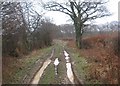
4
Byway leading to Bromley Green Road
This track leads from the A2070.
Image: © David Anstiss
Taken: 21 Feb 2010
0.10 miles
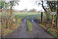
5
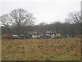
Athfas Farm
As seen from a footpath from Lone Barn Farm to a byway near the farm and Bromley Green Road.
Image: © David Anstiss
Taken: 21 Feb 2010
0.15 miles
6
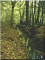
Stream in Bromley Green Woods
You can just make out the bridge where footpath 552 crosses ahead.
Image: © Adam Colton
Taken: 29 Oct 2005
0.15 miles
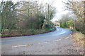
7
Byway to the A2070
This track leads from Bromley Green Road near Athfas Farm.
Image: © David Anstiss
Taken: 21 Feb 2010
0.17 miles